West Hallam night lights from space
Night Light of West Hallam (England) from space (United Kingdom) Src. Average luminocity for 10x10km area is 38.9034% and for 50x50km: 28.5536%.
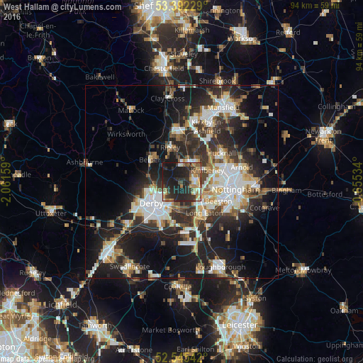
Analysis of West Hallam night lights 2016
Square area 10x10 km:
 2.12%
2.12%90-99
6.61%80-89
4.1%70-79
6.08%60-69
6.35%50-59
4.89%40-49
6.08%30-39
7.8%20-29
26.46%10-19
29.23%0-9
0.26%Square area 50x50 km:
5.44%90-99
5.86%80-89
2.86%70-79
2.72%60-69
3.09%50-59
3.15%40-49
3.66%30-39
4.93%20-29
10.69%10-19
17.61%0-9
40.01%Clear (daylight) street map image can be seen on geolist.org.
Map coordinates:
53° 23' 32.2" North, 2° 3' 41.7" West
52° 58' 15.3" North, 1° 21' 30.5" West
52° 32' 43.5" North, 0° 39' 19.2" West
Some cities around West Hallam sort by population:
• Derby
9.6 km =6 mi,  235°
235°
• Ilkeston
3.3 km =2.1 mi,  90°
90°
• Heanor
4.8 km =3 mi,  3°
3°
• Ripley
7.5 km =4.7 mi,  338°
338°
• Eastwood
5.1 km =3.2 mi,  50°
50°
• Kimberley
6.3 km =3.9 mi,  77°
77°
• Borrowash
7.3 km =4.5 mi,  193°
193°
• Kilburn
6.6 km =4.1 mi,  305°
305°
2634405 (p: 6,314)
Sources (retrieved 2019-11-25):
» Earth at Night: Flat Maps 2012, 2016