Heanor night lights from space
Night Light of Heanor (England) from space (United Kingdom) Src. Average luminocity for 10x10km area is 37.3108% and for 50x50km: 27.486%.

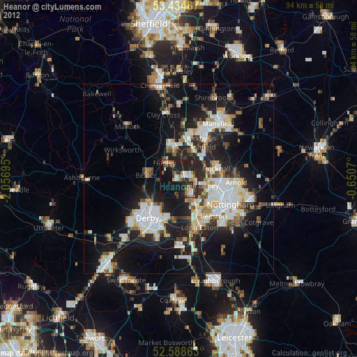
Analysis of Heanor night lights 2016
Square area 10x10 km:
 3.04%
3.04%90-99
5.42%80-89
1.46%70-79
4.1%60-69
6.88%50-59
7.67%40-49
6.88%30-39
8.99%20-29
26.06%10-19
29.23%0-9
0.26%Square area 50x50 km:
5.09%90-99
5.64%80-89
2.68%70-79
2.61%60-69
2.91%50-59
3.17%40-49
3.55%30-39
5%20-29
10.66%10-19
16.78%0-9
41.92%Clear (daylight) street map image can be seen on geolist.org.
Map coordinates:
53° 26' 4.8" North, 2° 3' 25" West
53° 0' 49.4" North, 1° 21' 13.8" West
52° 35' 19.1" North, 0° 39' 2.5" West
Some cities around Heanor sort by population:
• Ilkeston
5.6 km =3.5 mi,  148°
148°
• Belper
8.6 km =5.3 mi,  277°
277°
• Ripley
3.8 km =2.4 mi,  305°
305°
• Eastwood
3.9 km =2.4 mi,  112°
112°
• Pinxton
8.9 km =5.5 mi,  15°
15°
• Kimberley
6.7 km =4.2 mi,  120°
120°
• West Hallam
4.8 km =3 mi,  183°
183°
• Kilburn
5.7 km =3.5 mi,  261°
261°
2647227 (p: 23,122)
Sources (retrieved 2019-11-25):
» Earth at Night: Flat Maps 2012, 2016