Kimberley night lights from space
Night Light of Kimberley (England) from space (United Kingdom) Src. Average luminocity for 10x10km area is 70.9775% and for 50x50km: 27.7411%.
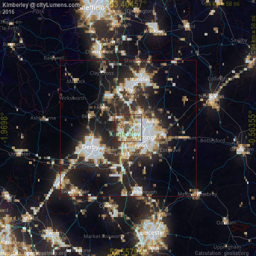
Analysis of Kimberley night lights 2016
Square area 10x10 km:
 11.9%
11.9%90-99
21.03%80-89
12.04%70-79
11.77%60-69
10.45%50-59
10.05%40-49
8.33%30-39
7.94%20-29
6.48%10-19
0%0-9
0%Square area 50x50 km:
5.21%90-99
5.59%80-89
2.77%70-79
2.75%60-69
3.05%50-59
3.2%40-49
3.63%30-39
4.91%20-29
10.55%10-19
16.01%0-9
42.34%Clear (daylight) street map image can be seen on geolist.org.
Map coordinates:
53° 24' 16.5" North, 1° 58' 11.3" West
52° 58' 60" North, 1° 16' 0" West
52° 33' 28.6" North, 0° 33' 48.8" West
Some cities around Kimberley sort by population:
• Nottingham
8.5 km =5.3 mi,  113°
113°
• Ilkeston
3.2 km =2 mi,  243°
243°
• Hucknall
7.1 km =4.4 mi,  38°
38°
• Heanor
6.7 km =4.2 mi,  300°
300°
• Eastwood
2.9 km =1.8 mi,  309°
309°
• Basford
5.9 km =3.7 mi, 108°
• New Basford
6.9 km =4.3 mi,  99°
99°
• West Hallam
6.3 km =3.9 mi,  257°
257°
2645539 (p: 11,273)
Sources (retrieved 2019-11-25):
» Earth at Night: Flat Maps 2012, 2016