Borrowash night lights from space
Night Light of Borrowash (England) from space (United Kingdom) Src. Average luminocity for 10x10km area is 55.8434% and for 50x50km: 28.3443%.
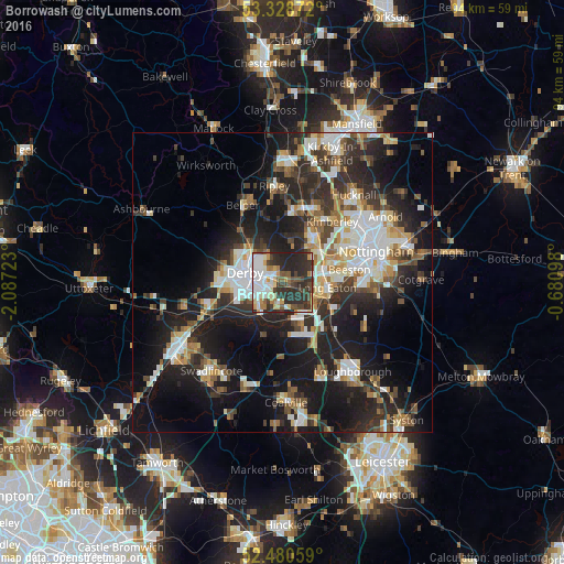
Analysis of Borrowash night lights 2016
Square area 10x10 km:
 14.52%
90-99
11.87%80-89
4.67%70-79
5.68%60-69
4.92%50-59
5.56%40-49
8.84%30-39
11.62%20-29
29.42%10-19
2.9%0-9
0%Square area 50x50 km:
5.14%90-99
5.55%80-89
2.74%70-79
2.59%60-69
3.25%50-59
3.4%40-49
3.66%30-39
4.98%20-29
10.81%10-19
19.19%0-9
38.71%Clear (daylight) street map image can be seen on geolist.org.
Map coordinates:
53° 19' 43.4" North, 2° 5' 14" West
52° 54' 24.2" North, 1° 23' 2.8" West
52° 28' 50.1" North, 0° 40' 51.5" West
Some cities around Borrowash sort by population:
• Derby
6.5 km =4 mi,  286°
286°
• Long Eaton
7.6 km =4.7 mi,  96°
96°
• Ilkeston
8.7 km =5.4 mi,  35°
35°
• Sinfin
7.4 km =4.6 mi,  247°
247°
• Kimberley
11.6 km =7.2 mi, 42°
• Castle Donington
7.6 km =4.7 mi,  158°
158°
• West Hallam
7.3 km =4.5 mi,  13°
13°
• Kilburn
11.6 km =7.2 mi,  341°
341°
2655168 (p: 5,746)
Sources (retrieved 2019-11-25):
» Earth at Night: Flat Maps 2012, 2016