Kilburn night lights from space
Night Light of Kilburn (England) from space (United Kingdom) Src. Average luminocity for 10x10km area is 22.7685% and for 50x50km: 26.6525%.
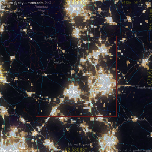
Analysis of Kilburn night lights 2016
Square area 10x10 km:
 0.26%
0.26%90-99
0.93%80-89
1.06%70-79
0.66%60-69
4.23%50-59
3.44%40-49
4.37%30-39
6.22%20-29
16.8%10-19
49.6%0-9
12.43%Square area 50x50 km:
5.05%90-99
5.53%80-89
2.63%70-79
2.6%60-69
2.86%50-59
2.85%40-49
3.41%30-39
4.81%20-29
10.52%10-19
16.06%0-9
43.68%Clear (daylight) street map image can be seen on geolist.org.
Map coordinates:
53° 25' 36.6" North, 2° 8' 30.6" West
53° 0' 20.9" North, 1° 26' 19.3" West
52° 34' 50.3" North, 0° 44' 8.1" West
Some cities around Kilburn sort by population:
• Derby
9.6 km =6 mi,  195°
195°
• Ilkeston
9.5 km =5.9 mi,  114°
114°
• Belper
3.4 km =2.1 mi,  304°
304°
• Heanor
5.7 km =3.5 mi,  81°
81°
• Alfreton
10.9 km =6.8 mi,  19°
19°
• Ripley
4 km =2.5 mi,  40°
40°
• Eastwood
9.3 km =5.8 mi,  93°
93°
• West Hallam
6.6 km =4.1 mi,  125°
125°
2645703 (p: 5,552)
Sources (retrieved 2019-11-25):
» Earth at Night: Flat Maps 2012, 2016