West End of London night lights from space
Night Light of West End of London (England) from space (United Kingdom) Src. Average luminocity for 10x10km area is 99.7914% and for 50x50km: 71.1415%.
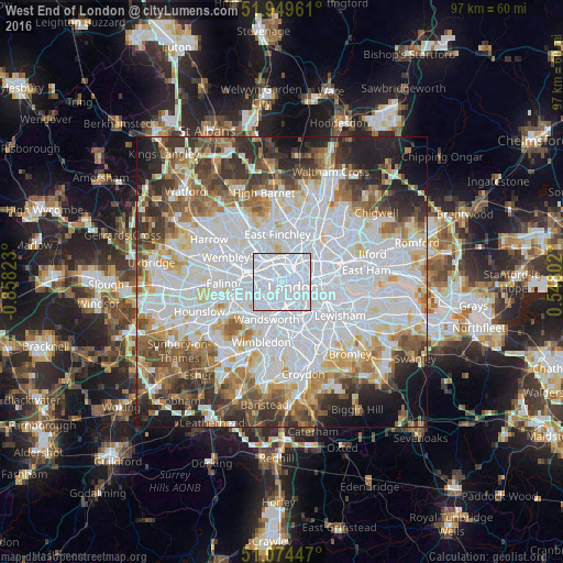
Analysis of West End of London night lights 2016
Square area 10x10 km:
 87.83%
90-99
11.76%80-89
0.4%70-79
0%60-69
0%50-59
0%40-49
0%30-39
0%20-29
0%10-19
0%0-9
0%Square area 50x50 km:
28.71%90-99
17.2%80-89
6.88%70-79
5.69%60-69
6.88%50-59
6.75%40-49
6.06%30-39
6.23%20-29
6.81%10-19
6.07%0-9
2.73%Clear (daylight) street map image can be seen on geolist.org.
Map coordinates:
51° 56' 58.6" North, 0° 51' 29.6" West
51° 30' 50.9" North, 0° 9' 18.4" West
51° 4' 28.1" North, 0° 32' 52.9" East
Some cities around West End of London sort by population:
• London
2.1 km =1.3 mi,  107°
107°
• City of Westminster
2.3 km =1.4 mi,  144°
144°
• Chelsea
3.1 km =1.9 mi,  198°
198°
• Camden Town
3 km =1.9 mi,  15°
15°
• Bayswater
2 km =1.2 mi,  260°
260°
• Belsize Park
3.9 km =2.4 mi,  342°
342°
• Barnsbury
4 km =2.5 mi,  41°
41°
• Lambeth
3.6 km =2.2 mi,  123°
123°
6615338 (p: 10,575)
Sources (retrieved 2019-11-25):
» Earth at Night: Flat Maps 2012, 2016