Belsize Park night lights from space
Night Light of Belsize Park (England) from space (United Kingdom) Src. Average luminocity for 10x10km area is 99.369% and for 50x50km: 71.7256%.
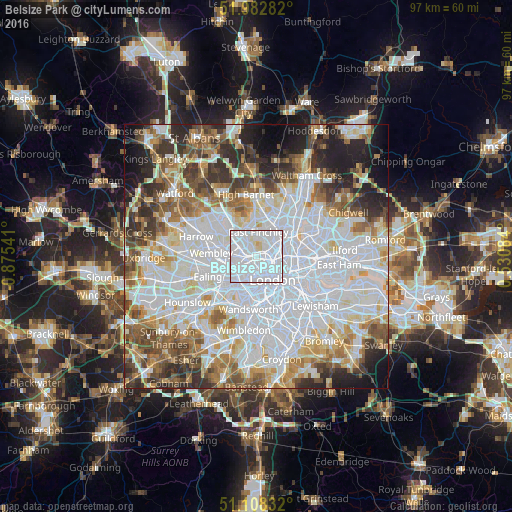
Analysis of Belsize Park night lights 2016
Square area 10x10 km:
 78.74%
90-99
18.98%80-89
2.14%70-79
0.13%60-69
0%50-59
0%40-49
0%30-39
0%20-29
0%10-19
0%0-9
0%Square area 50x50 km:
29.15%90-99
17.4%80-89
6.92%70-79
5.67%60-69
6.91%50-59
6.84%40-49
5.88%30-39
6.07%20-29
6.96%10-19
5.82%0-9
2.38%Clear (daylight) street map image can be seen on geolist.org.
Map coordinates:
51° 58' 58.2" North, 0° 52' 31.5" West
51° 32' 51.6" North, 0° 10' 20.2" West
51° 6' 30" North, 0° 31' 51" East
Some cities around Belsize Park sort by population:
• Islington
5 km =3.1 mi,  104°
104°
• Archway
3.4 km =2.1 mi,  50°
50°
• Holloway
3.3 km =2.1 mi,  80°
80°
• Camden Town
2.2 km =1.4 mi,  111°
111°
• Bayswater
4.1 km =2.5 mi,  191°
191°
• West End of London
3.9 km =2.4 mi,  162°
162°
• Crouch End
4.9 km =3 mi,  43°
43°
• Barnsbury
3.9 km =2.4 mi, 101°
6690581 (p: 11,600)
Sources (retrieved 2019-11-25):
» Earth at Night: Flat Maps 2012, 2016