Barnsbury night lights from space
Night Light of Barnsbury (England) from space (United Kingdom) Src. Average luminocity for 10x10km area is 99.3222% and for 50x50km: 71.1422%.
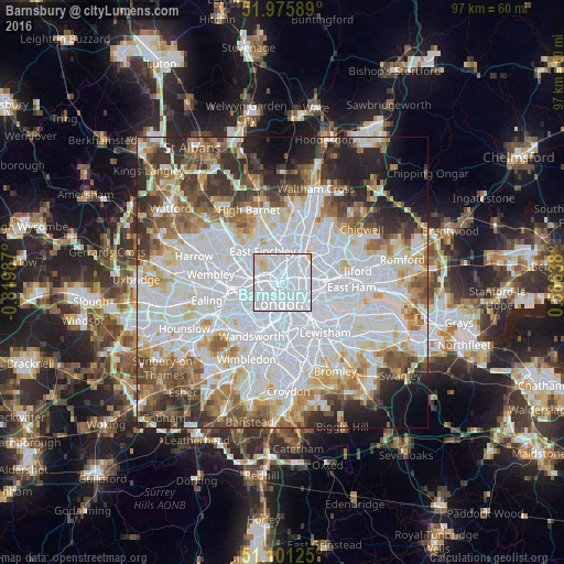
Analysis of Barnsbury night lights 2016
Square area 10x10 km:
 84.22%
90-99
12.7%80-89
2.94%70-79
0.13%60-69
0%50-59
0%40-49
0%30-39
0%20-29
0%10-19
0%0-9
0%Square area 50x50 km:
29.1%90-99
17.44%80-89
6.96%70-79
5.71%60-69
6.88%50-59
6.65%40-49
5.27%30-39
5.66%20-29
6.74%10-19
5.46%0-9
4.15%Clear (daylight) street map image can be seen on geolist.org.
Map coordinates:
51° 58' 33.2" North, 0° 49' 11.5" West
51° 32' 26.4" North, 0° 7' 0.3" West
51° 6' 4.5" North, 0° 35' 11" East
Some cities around Barnsbury sort by population:
• London
3.6 km =2.2 mi,  189°
189°
• Islington
1.1 km =0.7 mi,  117°
117°
• Archway
3.2 km =2 mi,  337°
337°
• Holloway
1.4 km =0.9 mi, 336°
• Camden Town
1.8 km =1.1 mi,  269°
269°
• Belsize Park
3.9 km =2.4 mi,  281°
281°
• West End of London
4 km =2.5 mi,  221°
221°
• City of London
3.5 km =2.2 mi,  150°
150°
6690590 (p: 10,000)
Sources (retrieved 2019-11-25):
» Earth at Night: Flat Maps 2012, 2016