Wednesbury night lights from space
Night Light of Wednesbury (England) from space (United Kingdom) Src. Average luminocity for 10x10km area is 97.3915% and for 50x50km: 40.3526%.
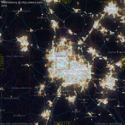

Analysis of Wednesbury night lights 2016
Square area 10x10 km:
 57.54%
90-99
34.13%80-89
4.1%70-79
3.17%60-69
1.06%50-59
0%40-49
0%30-39
0%20-29
0%10-19
0%0-9
0%Square area 50x50 km:
12.75%90-99
10.69%80-89
3.38%70-79
3.48%60-69
3.7%50-59
3.13%40-49
3.7%30-39
3.67%20-29
8.1%10-19
14.85%0-9
32.55%Clear (daylight) street map image can be seen on geolist.org.
Map coordinates:
52° 58' 36.7" North, 2° 43' 36" West
52° 33' 5" North, 2° 1' 24.8" West
52° 7' 18.4" North, 1° 19' 13.5" West
Some cities around Wednesbury sort by population:
• Dudley
7 km =4.3 mi,  215°
215°
• Walsall
4.6 km =2.9 mi,  35°
35°
• West Bromwich
4.1 km =2.5 mi,  151°
151°
• Tipton
3.9 km =2.4 mi,  230°
230°
• Bloxwich
7.5 km =4.7 mi,  9°
9°
• Willenhall
4.5 km =2.8 mi,  327°
327°
• Smethwick
7.6 km =4.7 mi, 149°
• Oldbury
5.7 km =3.5 mi,  175°
175°
2634617 (p: 24,337)
Sources (retrieved 2019-11-25):
» Earth at Night: Flat Maps 2012, 2016