Weaverham night lights from space
Night Light of Weaverham (England) from space (United Kingdom) Src. Average luminocity for 10x10km area is 23.9735% and for 50x50km: 36.3091%.
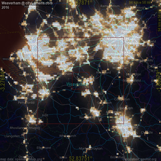
Analysis of Weaverham night lights 2016
Square area 10x10 km:
 2.02%
2.02%90-99
3.66%80-89
3.54%70-79
2.02%60-69
1.39%50-59
2.4%40-49
4.42%30-39
3.54%20-29
12.12%10-19
29.67%0-9
35.23%Square area 50x50 km:
10.48%90-99
8.78%80-89
3.09%70-79
2.88%60-69
3.13%50-59
3.18%40-49
4.72%30-39
6.11%20-29
7.74%10-19
13.4%0-9
36.5%Clear (daylight) street map image can be seen on geolist.org.
Map coordinates:
53° 40' 43.4" North, 3° 16' 33.7" West
53° 15' 36.6" North, 2° 34' 22.5" West
52° 50' 15" North, 1° 52' 11.2" West
Some cities around Weaverham sort by population:
• Runcorn
13.9 km =8.6 mi,  310°
310°
• Northwich
3.5 km =2.2 mi,  92°
92°
• Winsford
8.3 km =5.2 mi,  156°
156°
• Middlewich
11.4 km =7.1 mi,  131°
131°
• Grappenhall
12.6 km =7.8 mi,  7°
7°
• Frodsham
11 km =6.8 mi,  290°
290°
• Stockton Heath
12.3 km =7.6 mi,  359°
359°
• Helsby
13.1 km =8.1 mi,  276°
276°
2634623 (p: 6,087)
Sources (retrieved 2019-11-25):
» Earth at Night: Flat Maps 2012, 2016