Grappenhall night lights from space
Night Light of Grappenhall (England) from space (United Kingdom) Src. Average luminocity for 10x10km area is 52.7209% and for 50x50km: 47.5997%.
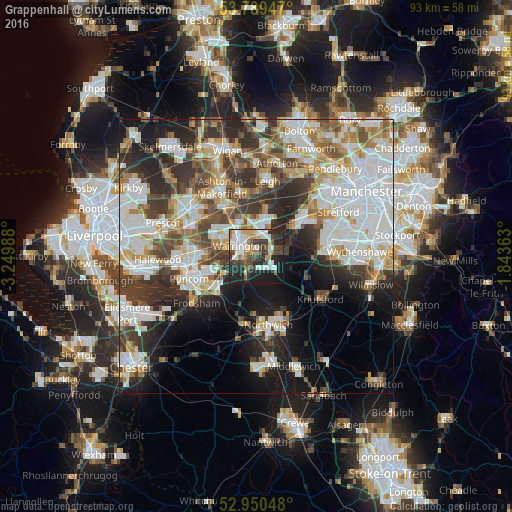
Analysis of Grappenhall night lights 2016
Square area 10x10 km:
 12.04%
90-99
11.9%80-89
5.29%70-79
4.63%60-69
5.29%50-59
6.35%40-49
8.99%30-39
10.05%20-29
17.72%10-19
16.93%0-9
0.79%Square area 50x50 km:
13.4%90-99
11.35%80-89
4.53%70-79
4.65%60-69
5.22%50-59
4.64%40-49
6.39%30-39
7.69%20-29
9.65%10-19
11.48%0-9
21.01%Clear (daylight) street map image can be seen on geolist.org.
Map coordinates:
53° 47' 22.1" North, 3° 14' 59.6" West
53° 22' 19.3" North, 2° 32' 48.3" West
52° 57' 1.7" North, 1° 50' 37.1" West
Some cities around Grappenhall sort by population:
• Warrington
3.2 km =2 mi,  315°
315°
• Great Sankey
6.6 km =4.1 mi,  290°
290°
• Newton-le-Willows
9.4 km =5.8 mi,  337°
337°
• Irlam
11.3 km =7 mi,  46°
46°
• Lymm
4.7 km =2.9 mi,  77°
77°
• Partington
9.4 km =5.8 mi,  56°
56°
• Culcheth
9 km =5.6 mi,  10°
10°
• Stockton Heath
1.8 km =1.1 mi,  265°
265°
6693989 (p: 9,377)
Sources (retrieved 2019-11-25):
» Earth at Night: Flat Maps 2012, 2016