Stockton Heath night lights from space
Night Light of Stockton Heath (England) from space (United Kingdom) Src. Average luminocity for 10x10km area is 58.4762% and for 50x50km: 47.8682%.
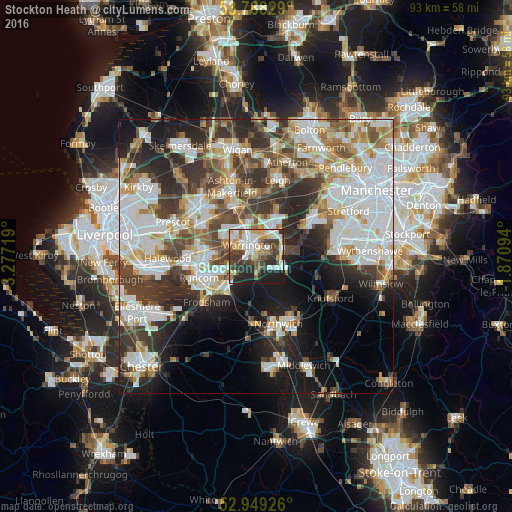
Analysis of Stockton Heath night lights 2016
Square area 10x10 km:
 12.57%
90-99
13.76%80-89
7.14%70-79
7.41%60-69
6.08%50-59
6.48%40-49
8.99%30-39
12.57%20-29
14.42%10-19
10.58%0-9
0%Square area 50x50 km:
13.4%90-99
11.28%80-89
4.58%70-79
4.65%60-69
5.18%50-59
4.7%40-49
6.69%30-39
7.96%20-29
9.96%10-19
11.58%0-9
20.02%Clear (daylight) street map image can be seen on geolist.org.
Map coordinates:
53° 47' 17.8" North, 3° 16' 37.9" West
53° 22' 15" North, 2° 34' 26.6" West
52° 56' 57.3" North, 1° 52' 15.4" West
Some cities around Stockton Heath sort by population:
• Warrington
2.4 km =1.5 mi,  350°
350°
• Runcorn
10.9 km =6.8 mi,  252°
252°
• Widnes
10.7 km =6.6 mi,  264°
264°
• Great Sankey
5 km =3.1 mi,  298°
298°
• Newton-le-Willows
9 km =5.6 mi, 348°
• Lymm
6.5 km =4 mi,  79°
79°
• Grappenhall
1.8 km =1.1 mi,  85°
85°
• Culcheth
9.6 km =6 mi,  21°
21°
8224784 (p: 6,396)
Sources (retrieved 2019-11-25):
» Earth at Night: Flat Maps 2012, 2016