Middlewich night lights from space
Night Light of Middlewich (England) from space (United Kingdom) Src. Average luminocity for 10x10km area is 23.2222% and for 50x50km: 25.9497%.
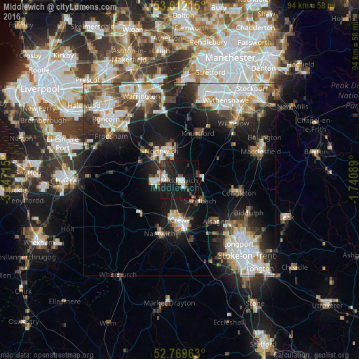
Analysis of Middlewich night lights 2016
Square area 10x10 km:
 3.03%
3.03%90-99
4.55%80-89
1.52%70-79
0%60-69
2.15%50-59
1.64%40-49
3.66%30-39
2.15%20-29
9.22%10-19
45.96%0-9
26.14%Square area 50x50 km:
5.8%90-99
5.85%80-89
2.53%70-79
2.23%60-69
2.49%50-59
2.83%40-49
3.46%30-39
3.7%20-29
6.66%10-19
15.07%0-9
49.38%Clear (daylight) street map image can be seen on geolist.org.
Map coordinates:
53° 36' 43.7" North, 3° 8' 49.7" West
53° 11' 34.7" North, 2° 26' 38.5" West
52° 46' 10.7" North, 1° 44' 27.2" West
Some cities around Middlewich sort by population:
• Crewe
10.6 km =6.6 mi,  179°
179°
• Northwich
8.9 km =5.5 mi,  325°
325°
• Winsford
5.3 km =3.3 mi,  268°
268°
• Sandbach
7.6 km =4.7 mi,  134°
134°
• Alsager
14.1 km =8.8 mi,  139°
139°
• Knutsford
13.1 km =8.1 mi,  20°
20°
• Weaverham
11.4 km =7.1 mi,  311°
311°
• Holmes Chapel
5.8 km =3.6 mi,  80°
80°
2642573 (p: 13,595)
Sources (retrieved 2019-11-25):
» Earth at Night: Flat Maps 2012, 2016