Waltham Cross night lights from space
Night Light of Waltham Cross (England) from space (United Kingdom) Src. Average luminocity for 10x10km area is 60.7815% and for 50x50km: 51.4678%.
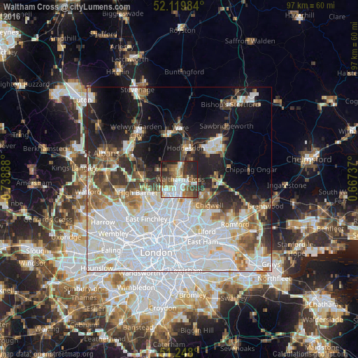
Analysis of Waltham Cross night lights 2016
Square area 10x10 km:
 14.01%
90-99
14.71%80-89
5.74%70-79
3.5%60-69
10.5%50-59
10.08%40-49
9.24%30-39
13.03%20-29
13.73%10-19
5.46%0-9
0%Square area 50x50 km:
21.52%90-99
12%80-89
4.3%70-79
3.03%60-69
4.17%50-59
4.55%40-49
3.9%30-39
4.51%20-29
6.7%10-19
11.85%0-9
23.46%Clear (daylight) street map image can be seen on geolist.org.
Map coordinates:
52° 7' 11.4" North, 0° 44' 20" West
51° 41' 9.7" North, 0° 2' 8.7" West
51° 14' 52.8" North, 0° 40' 2.5" East
Some cities around Waltham Cross sort by population:
• Enfield Town
5.1 km =3.2 mi,  221°
221°
• Cheshunt
1.6 km =1 mi,  13°
13°
• Hoddesdon
8.6 km =5.3 mi, 11°
• Woodford Green
9.4 km =5.8 mi,  154°
154°
• Potters Bar
9.9 km =6.2 mi,  274°
274°
• Hadley Wood
9.5 km =5.9 mi,  256°
256°
• Broxbourne
6.9 km =4.3 mi, 9°
• Buckhurst Hill
8.3 km =5.2 mi, 145°
2634842 (p: 10,000)
Sources (retrieved 2019-11-25):
» Earth at Night: Flat Maps 2012, 2016