Culcheth night lights from space
Night Light of Culcheth (England) from space (United Kingdom) Src. Average luminocity for 10x10km area is 48.1389% and for 50x50km: 49.1696%.
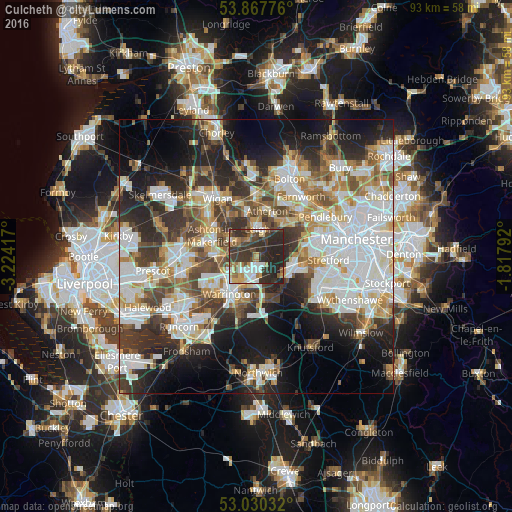
Analysis of Culcheth night lights 2016
Square area 10x10 km:
 7.8%
7.8%90-99
5.95%80-89
4.23%70-79
5.56%60-69
8.99%50-59
4.37%40-49
8.47%30-39
20.37%20-29
30.56%10-19
3.7%0-9
0%Square area 50x50 km:
13.28%90-99
11.33%80-89
4.64%70-79
5%60-69
5.66%50-59
5.21%40-49
6.48%30-39
7.51%20-29
11.59%10-19
13.55%0-9
15.75%Clear (daylight) street map image can be seen on geolist.org.
Map coordinates:
53° 52' 3.9" North, 3° 13' 27" West
53° 27' 4" North, 2° 31' 15.7" West
53° 1' 49.2" North, 1° 49' 4.5" West
Some cities around Culcheth sort by population:
• Warrington
7.6 km =4.7 mi,  211°
211°
• Leigh
5 km =3.1 mi,  0°
0°
• Tyldesley
7.8 km =4.8 mi,  26°
26°
• Golborne
5.8 km =3.6 mi,  299°
299°
• Newton-le-Willows
5.2 km =3.2 mi,  268°
268°
• Irlam
6.5 km =4 mi,  98°
98°
• Abram
8 km =5 mi,  323°
323°
• Partington
7.1 km =4.4 mi,  120°
120°
2651763 (p: 6,708)
Sources (retrieved 2019-11-25):
» Earth at Night: Flat Maps 2012, 2016