Lymm night lights from space
Night Light of Lymm (England) from space (United Kingdom) Src. Average luminocity for 10x10km area is 39.2368% and for 50x50km: 47.6939%.
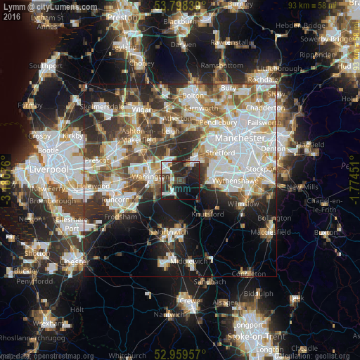
Analysis of Lymm night lights 2016
Square area 10x10 km:
 8.99%
8.99%90-99
7.54%80-89
2.25%70-79
1.98%60-69
2.51%50-59
3.84%40-49
6.08%30-39
12.3%20-29
19.58%10-19
23.68%0-9
11.24%Square area 50x50 km:
13.1%90-99
11.24%80-89
4.87%70-79
5.04%60-69
5.27%50-59
5.07%40-49
6.43%30-39
6.49%20-29
9.76%10-19
11.57%0-9
21.16%Clear (daylight) street map image can be seen on geolist.org.
Map coordinates:
53° 47' 54.2" North, 3° 10' 50.7" West
53° 22' 51.8" North, 2° 28' 39.5" West
52° 57' 34.5" North, 1° 46' 28.2" West
Some cities around Lymm sort by population:
• Warrington
6.9 km =4.3 mi,  280°
280°
• Altrincham
8.6 km =5.3 mi,  85°
85°
• Irlam
7.7 km =4.8 mi,  27°
27°
• Grappenhall
4.7 km =2.9 mi,  257°
257°
• Partington
5.3 km =3.3 mi,  37°
37°
• Culcheth
8.3 km =5.2 mi,  339°
339°
• Stockton Heath
6.5 km =4 mi, 259°
• Bowdon
7.5 km =4.7 mi, 93°
2643309 (p: 11,608)
Sources (retrieved 2019-11-25):
» Earth at Night: Flat Maps 2012, 2016