Bridgnorth night lights from space
Night Light of Bridgnorth (England) from space (United Kingdom) Src. Average luminocity for 10x10km area is 3.4643% and for 50x50km: 15.1789%.
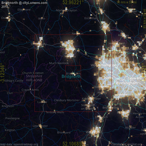
Analysis of Bridgnorth night lights 2016
Square area 10x10 km:
 0.4%
0.4%90-99
0.26%80-89
0.4%70-79
0.53%60-69
0.53%50-59
0.13%40-49
0.93%30-39
0.53%20-29
1.59%10-19
0%0-9
94.71%Square area 50x50 km:
3.53%90-99
3.45%80-89
1.49%70-79
1.58%60-69
1.5%50-59
1.56%40-49
1.79%30-39
1.8%20-29
3.27%10-19
8.35%0-9
71.68%Clear (daylight) street map image can be seen on geolist.org.
Map coordinates:
52° 57' 44" North, 3° 7' 24.5" West
52° 32' 11.8" North, 2° 25' 13.2" West
52° 6' 24.7" North, 1° 43' 2" West
Some cities around Bridgnorth sort by population:
• Telford
15.7 km =9.8 mi,  352°
352°
• Kingswinford
17.6 km =10.9 mi,  104°
104°
• Ryton
10.1 km =6.3 mi,  28°
28°
• Wombourn
16 km =9.9 mi,  91°
91°
• Codsall
18.1 km =11.2 mi,  54°
54°
• Oakengates
17.7 km =11 mi, 353°
• Shifnal
15.2 km =9.4 mi,  12°
12°
• Broseley
9.5 km =5.9 mi,  333°
333°
2654731 (p: 12,657)
Sources (retrieved 2019-11-25):
» Earth at Night: Flat Maps 2012, 2016