Oakengates night lights from space
Night Light of Oakengates (England) from space (United Kingdom) Src. Average luminocity for 10x10km area is 53.6085% and for 50x50km: 12.2252%.
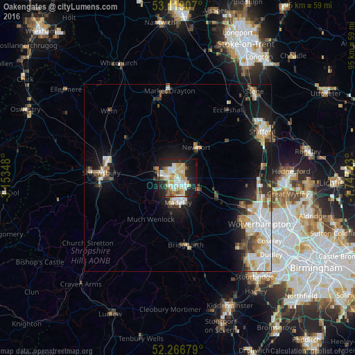
Analysis of Oakengates night lights 2016
Square area 10x10 km:
 8.86%
8.86%90-99
15.21%80-89
9.92%70-79
9.52%60-69
4.1%50-59
4.63%40-49
1.85%30-39
3.31%20-29
19.05%10-19
20.24%0-9
3.31%Square area 50x50 km:
2.62%90-99
2.76%80-89
1.24%70-79
1.5%60-69
1.17%50-59
1.22%40-49
1.33%30-39
1.29%20-29
2.45%10-19
7.35%0-9
77.05%Clear (daylight) street map image can be seen on geolist.org.
Map coordinates:
53° 7' 8.7" North, 3° 9' 12.5" West
52° 41' 42" North, 2° 27' 1.3" West
52° 16' 0.4" North, 1° 44' 50" West
Some cities around Oakengates sort by population:
• Telford
2 km =1.2 mi,  177°
177°
• Wellington
4.5 km =2.8 mi,  277°
277°
• Ryton
11 km =6.8 mi,  142°
142°
• Hadley
2.3 km =1.4 mi, 284°
• Newport
9.4 km =5.8 mi,  31°
31°
• Bridgnorth
17.7 km =11 mi,  173°
173°
• Shifnal
5.9 km =3.7 mi,  117°
117°
• Broseley
9.4 km =5.8 mi,  193°
193°
2641130 (p: 8,517)
Sources (retrieved 2019-11-25):
» Earth at Night: Flat Maps 2012, 2016