Hadley night lights from space
Night Light of Hadley (England) from space (United Kingdom) Src. Average luminocity for 10x10km area is 51.5251% and for 50x50km: 9.7502%.
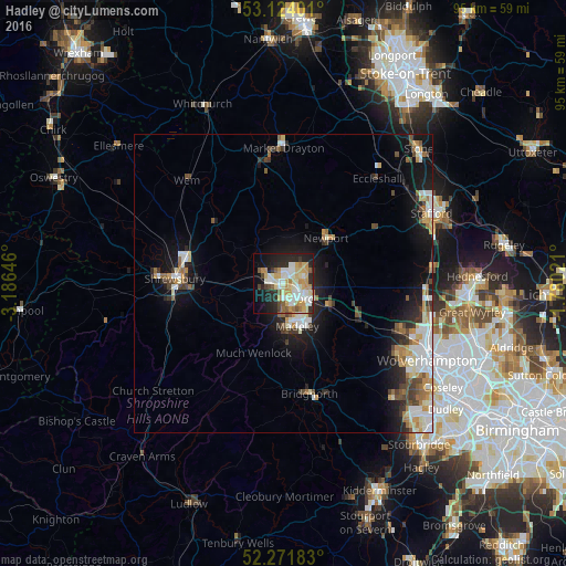
Analysis of Hadley night lights 2016
Square area 10x10 km:
 8.73%
8.73%90-99
14.55%80-89
9.92%70-79
9.39%60-69
3.57%50-59
4.5%40-49
2.65%30-39
3.17%20-29
15.61%10-19
15.34%0-9
12.57%Square area 50x50 km:
1.7%90-99
2.14%80-89
0.97%70-79
1.28%60-69
1.01%50-59
1%40-49
1.21%30-39
1.1%20-29
2.19%10-19
6.49%0-9
80.91%Clear (daylight) street map image can be seen on geolist.org.
Map coordinates:
53° 7' 26.4" North, 3° 11' 11.3" West
52° 42' 0" North, 2° 28' 60" West
52° 16' 18.6" North, 1° 46' 48.8" West
Some cities around Hadley sort by population:
• Telford
3.5 km =2.2 mi,  138°
138°
• Shrewsbury
18.1 km =11.2 mi,  273°
273°
• Wellington
2.2 km =1.4 mi, 270°
• Ryton
12.9 km =8 mi, 135°
• Newport
10.3 km =6.4 mi,  43°
43°
• Oakengates
2.3 km =1.4 mi,  104°
104°
• Shifnal
8.2 km =5.1 mi,  113°
113°
• Broseley
9.7 km =6 mi,  179°
179°
2647677 (p: 14,829)
Sources (retrieved 2019-11-25):
» Earth at Night: Flat Maps 2012, 2016