Ryhope night lights from space
Night Light of Ryhope (England) from space (United Kingdom) Src. Average luminocity for 10x10km area is 54.3349% and for 50x50km: 24.9561%.
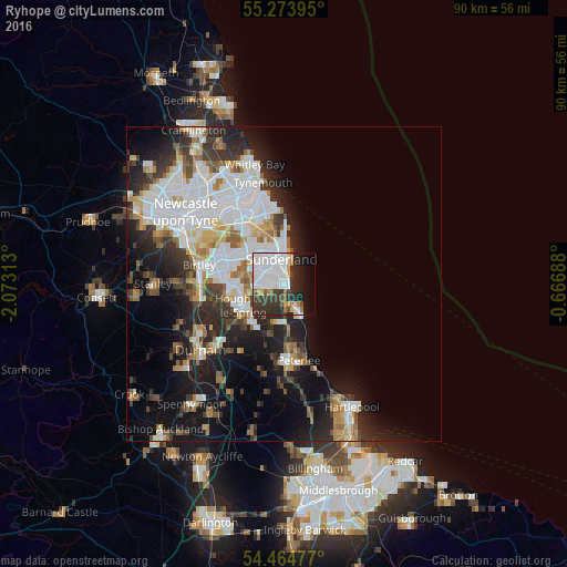
Analysis of Ryhope night lights 2016
Square area 10x10 km:
 26.32%
90-99
9.69%80-89
2.15%70-79
3.23%60-69
3.47%50-59
2.27%40-49
2.87%30-39
11.48%20-29
13.76%10-19
10.77%0-9
14%Square area 50x50 km:
7.39%90-99
5.28%80-89
1.98%70-79
2.11%60-69
2.42%50-59
2.36%40-49
2.23%30-39
4.23%20-29
6.38%10-19
11.38%0-9
54.24%Clear (daylight) street map image can be seen on geolist.org.
Map coordinates:
55° 16' 26.2" North, 2° 4' 23.3" West
54° 52' 17" North, 1° 22' 12" West
54° 27' 53.2" North, 0° 40' 0.8" West
Some cities around Ryhope sort by population:
• Sunderland
3.8 km =2.4 mi,  348°
348°
• Houghton-Le-Spring
7 km =4.3 mi,  240°
240°
• Seaham
3.9 km =2.4 mi,  156°
156°
• The Boldons
9.5 km =5.9 mi,  326°
326°
• Hetton-Le-Hole
8 km =5 mi,  220°
220°
• Murton
6.1 km =3.8 mi,  192°
192°
• Whitburn
9.1 km =5.7 mi,  0°
0°
• East Boldon
8.9 km =5.5 mi,  335°
335°
2638899 (p: 14,000)
Sources (retrieved 2019-11-25):
» Earth at Night: Flat Maps 2012, 2016