Whitburn night lights from space
Night Light of Whitburn (England) from space (United Kingdom) Src. Average luminocity for 10x10km area is 48.9043% and for 50x50km: 23.5389%.
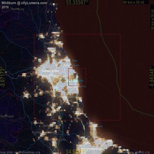
Analysis of Whitburn night lights 2016
Square area 10x10 km:
 18.42%
90-99
14.11%80-89
2.63%70-79
4.78%60-69
4.67%50-59
3.11%40-49
1.67%30-39
2.99%20-29
8.37%10-19
11.84%0-9
27.39%Square area 50x50 km:
7.34%90-99
5.18%80-89
1.99%70-79
1.95%60-69
2.13%50-59
2.17%40-49
2.03%30-39
3.62%20-29
6.24%10-19
8.74%0-9
58.61%Clear (daylight) street map image can be seen on geolist.org.
Map coordinates:
55° 21' 18.3" North, 2° 4' 18.2" West
54° 57' 12" North, 1° 22' 7" West
54° 32' 51.1" North, 0° 39' 55.7" West
Some cities around Whitburn sort by population:
• Sunderland
5.5 km =3.4 mi,  189°
189°
• South Shields
6.5 km =4 mi,  321°
321°
• North Shields
8.7 km =5.4 mi, 323°
• Jarrow
8 km =5 mi,  292°
292°
• Tynemouth
8 km =5 mi,  333°
333°
• Ryhope
9.1 km =5.7 mi,  180°
180°
• The Boldons
5.6 km =3.5 mi,  257°
257°
• East Boldon
3.9 km =2.4 mi, 255°
2634138 (p: 5,352)
Sources (retrieved 2019-11-25):
» Earth at Night: Flat Maps 2012, 2016