Hetton-Le-Hole night lights from space
Night Light of Hetton-Le-Hole (England) from space (United Kingdom) Src. Average luminocity for 10x10km area is 41.3983% and for 50x50km: 27.7352%.
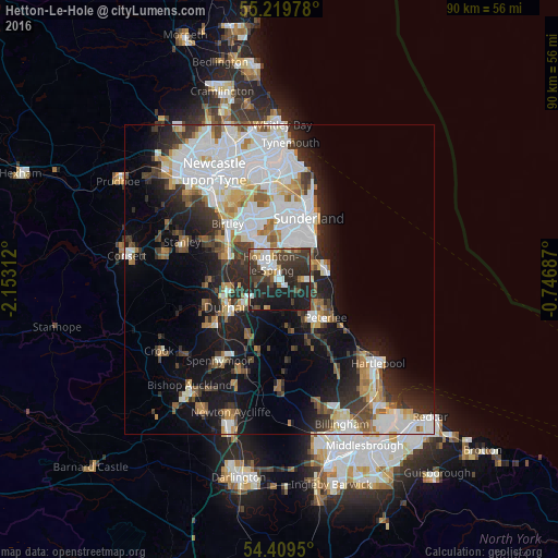
Analysis of Hetton-Le-Hole night lights 2016
Square area 10x10 km:
 7.18%
7.18%90-99
6.46%80-89
4.31%70-79
2.87%60-69
3.83%50-59
3.35%40-49
7.18%30-39
16.51%20-29
24.04%10-19
22.85%0-9
1.44%Square area 50x50 km:
8.19%90-99
6.08%80-89
2.22%70-79
2.33%60-69
2.78%50-59
2.59%40-49
2.59%30-39
4.38%20-29
6.24%10-19
12.07%0-9
50.53%Clear (daylight) street map image can be seen on geolist.org.
Map coordinates:
55° 13' 11.2" North, 2° 9' 11.2" West
54° 49' 0" North, 1° 27' 0" West
54° 24' 34.2" North, 0° 44' 48.7" West
Some cities around Hetton-Le-Hole sort by population:
• Durham
9.2 km =5.7 mi,  241°
241°
• Houghton-Le-Spring
2.8 km =1.7 mi,  340°
340°
• Peterlee
9.6 km =6 mi,  130°
130°
• Chester-le-Street
9.2 km =5.7 mi,  300°
300°
• Seaham
7.1 km =4.4 mi,  69°
69°
• Ryhope
8 km =5 mi,  40°
40°
• Murton
3.8 km =2.4 mi,  87°
87°
• Easington
6.8 km =4.2 mi,  120°
120°
2647021 (p: 13,100)
Sources (retrieved 2019-11-25):
» Earth at Night: Flat Maps 2012, 2016