Rastrick night lights from space
Night Light of Rastrick (England) from space (United Kingdom) Src. Average luminocity for 10x10km area is 72.9104% and for 50x50km: 38.5826%.
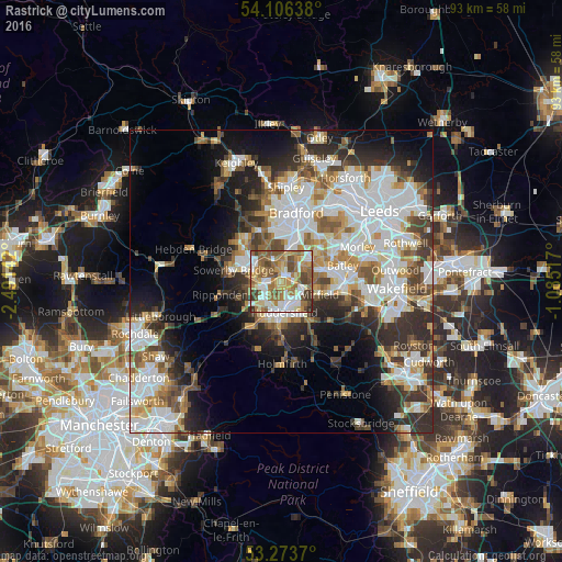
Analysis of Rastrick night lights 2016
Square area 10x10 km:
 14.52%
90-99
16.16%80-89
10.23%70-79
9.85%60-69
19.82%50-59
15.4%40-49
9.47%30-39
3.66%20-29
0.88%10-19
0%0-9
0%Square area 50x50 km:
10.32%90-99
9.04%80-89
3.43%70-79
4.08%60-69
4.65%50-59
4.84%40-49
4.45%30-39
5.51%20-29
7.59%10-19
9.86%0-9
36.22%Clear (daylight) street map image can be seen on geolist.org.
Map coordinates:
54° 6' 23" North, 2° 29' 29.1" West
53° 41' 31.6" North, 1° 47' 17.9" West
53° 16' 25.3" North, 1° 5' 6.6" West
Some cities around Rastrick sort by population:
• Huddersfield
4.8 km =3 mi,  176°
176°
• Halifax
4.9 km =3 mi,  303°
303°
• Brighouse
1.3 km =0.8 mi,  12°
12°
• Cleckheaton
6.1 km =3.8 mi,  54°
54°
• Mirfield
6.4 km =4 mi,  108°
108°
• Elland
3.4 km =2.1 mi,  256°
256°
• Liversedge
6.4 km =4 mi,  76°
76°
• Heckmondwike
7.5 km =4.7 mi, 77°
12060359 (p: 11,351)
Sources (retrieved 2019-11-25):
» Earth at Night: Flat Maps 2012, 2016