Heckmondwike night lights from space
Night Light of Heckmondwike (England) from space (United Kingdom) Src. Average luminocity for 10x10km area is 75.298% and for 50x50km: 39.7881%.
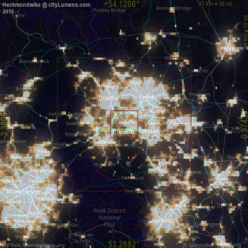
Analysis of Heckmondwike night lights 2016
Square area 10x10 km:
 18.06%
90-99
20.08%80-89
7.32%70-79
17.17%60-69
13.76%50-59
6.94%40-49
7.45%30-39
7.07%20-29
2.15%10-19
0%0-9
0%Square area 50x50 km:
9.89%90-99
8.79%80-89
3.55%70-79
4.24%60-69
4.82%50-59
5.07%40-49
4.95%30-39
6.68%20-29
10.32%10-19
10.38%0-9
31.32%Clear (daylight) street map image can be seen on geolist.org.
Map coordinates:
54° 7' 14.2" North, 2° 22' 50.2" West
53° 42' 23.3" North, 1° 40' 38.9" West
53° 17' 17.5" North, 0° 58' 27.7" West
Some cities around Heckmondwike sort by population:
• Morley
6.4 km =4 mi,  54°
54°
• Dewsbury
3.6 km =2.2 mi,  118°
118°
• Batley
2.9 km =1.8 mi,  97°
97°
• Brighouse
7 km =4.3 mi,  267°
267°
• Cleckheaton
3 km =1.9 mi,  309°
309°
• Ossett
7.1 km =4.4 mi,  114°
114°
• Mirfield
3.9 km =2.4 mi,  198°
198°
• Liversedge
1.1 km =0.7 mi,  261°
261°
2647198 (p: 11,542)
Sources (retrieved 2019-11-25):
» Earth at Night: Flat Maps 2012, 2016