Liversedge night lights from space
Night Light of Liversedge (England) from space (United Kingdom) Src. Average luminocity for 10x10km area is 74.9394% and for 50x50km: 39.3441%.
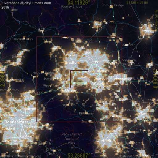
Analysis of Liversedge night lights 2016
Square area 10x10 km:
 17.3%
17.3%90-99
19.57%80-89
7.7%70-79
15.91%60-69
15.91%50-59
6.94%40-49
8.46%30-39
6.06%20-29
2.15%10-19
0%0-9
0%Square area 50x50 km:
9.77%90-99
8.7%80-89
3.41%70-79
4.14%60-69
4.77%50-59
5.15%40-49
5.04%30-39
6.74%20-29
9.88%10-19
10.37%0-9
32.03%Clear (daylight) street map image can be seen on geolist.org.
Map coordinates:
54° 7' 9.4" North, 2° 23' 47" West
53° 42' 18.5" North, 1° 41' 35.8" West
53° 17' 12.7" North, 0° 59' 24.5" West
Some cities around Liversedge sort by population:
• Morley
7.3 km =4.5 mi,  57°
57°
• Dewsbury
4.5 km =2.8 mi,  110°
110°
• Batley
3.9 km =2.4 mi,  93°
93°
• Brighouse
6 km =3.7 mi,  267°
267°
• Cleckheaton
2.5 km =1.6 mi,  328°
328°
• Mirfield
3.5 km =2.2 mi,  183°
183°
• Heckmondwike
1.1 km =0.7 mi,  81°
81°
• Rastrick
6.4 km =4 mi,  256°
256°
2644207 (p: 11,656)
Sources (retrieved 2019-11-25):
» Earth at Night: Flat Maps 2012, 2016