Radstock night lights from space
Night Light of Radstock (England) from space (United Kingdom) Src. Average luminocity for 10x10km area is 8.1541% and for 50x50km: 10.7388%.
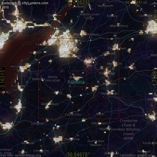
Analysis of Radstock night lights 2016
Square area 10x10 km:
 0%
0%90-99
0.84%80-89
0.28%70-79
0.42%60-69
0.7%50-59
3.36%40-49
3.78%30-39
1.4%20-29
2.1%10-19
1.12%0-9
85.99%Square area 50x50 km:
1.57%90-99
1.86%80-89
1.19%70-79
1.09%60-69
1.51%50-59
1.74%40-49
1.84%30-39
1.23%20-29
2.21%10-19
4.05%0-9
81.71%Clear (daylight) street map image can be seen on geolist.org.
Map coordinates:
51° 43' 34.5" North, 3° 9' 47.3" West
51° 17' 19" North, 2° 27' 36.1" West
50° 50' 48.4" North, 1° 45' 24.8" West
Some cities around Radstock sort by population:
• Mendip
12.9 km =8 mi,  243°
243°
• Bath
11.8 km =7.3 mi,  35°
35°
• Frome
11.7 km =7.3 mi,  124°
124°
• Keynsham
14.2 km =8.8 mi,  349°
349°
• Wells
15.9 km =9.9 mi, 235°
• Midsomer Norton
1.8 km =1.1 mi,  259°
259°
• Shepton Mallet
12.6 km =7.8 mi,  208°
208°
• Peasedown Saint John
4 km =2.5 mi, 38°
2639715 (p: 5,275)
Sources (retrieved 2019-11-25):
» Earth at Night: Flat Maps 2012, 2016