Shepton Mallet night lights from space
Night Light of Shepton Mallet (England) from space (United Kingdom) Src. Average luminocity for 10x10km area is 5.2353% and for 50x50km: 4.6124%.
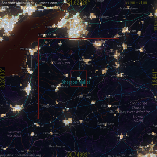
Analysis of Shepton Mallet night lights 2016
Square area 10x10 km:
 0.4%
0.4%90-99
0.67%80-89
0%70-79
1.6%60-69
1.87%50-59
0.8%40-49
0%30-39
0.53%20-29
0.53%10-19
0%0-9
93.58%Square area 50x50 km:
0.22%90-99
0.55%80-89
0.31%70-79
0.54%60-69
0.66%50-59
0.86%40-49
1.04%30-39
0.65%20-29
1.3%10-19
2.38%0-9
91.48%Clear (daylight) street map image can be seen on geolist.org.
Map coordinates:
51° 37' 41.8" North, 3° 15' 1.3" West
51° 11' 23" North, 2° 32' 50" West
50° 44' 48.9" North, 1° 50' 38.8" West
Some cities around Shepton Mallet sort by population:
• Mendip
7.6 km =4.7 mi,  313°
313°
• Frome
16.3 km =10.1 mi,  74°
74°
• Street
15.3 km =9.5 mi,  241°
241°
• Wells
7.4 km =4.6 mi,  285°
285°
• Midsomer Norton
11.5 km =7.1 mi,  21°
21°
• Glastonbury
13 km =8.1 mi,  248°
248°
• Peasedown Saint John
16.5 km =10.3 mi,  31°
31°
• Radstock
12.6 km =7.8 mi, 28°
2638035 (p: 10,369)
Sources (retrieved 2019-11-25):
» Earth at Night: Flat Maps 2012, 2016