Radcliffe on Trent night lights from space
Night Light of Radcliffe on Trent (England) from space (United Kingdom) Src. Average luminocity for 10x10km area is 33.2593% and for 50x50km: 23.1767%.
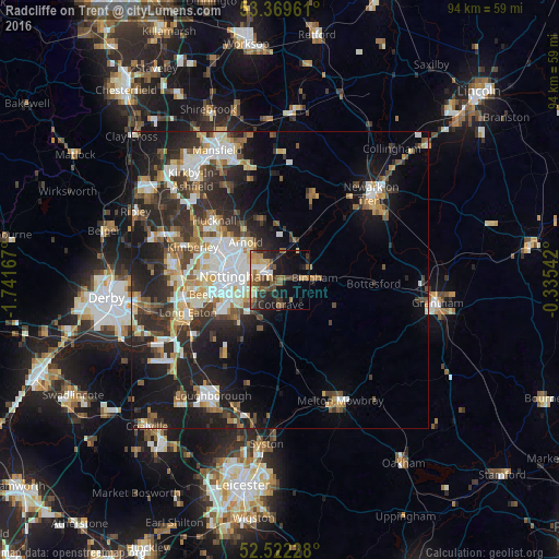
Analysis of Radcliffe on Trent night lights 2016
Square area 10x10 km:
 2.38%
2.38%90-99
3.17%80-89
4.37%70-79
4.5%60-69
6.08%50-59
10.19%40-49
5.56%30-39
6.22%20-29
11.51%10-19
17.86%0-9
28.17%Square area 50x50 km:
3.96%90-99
4.67%80-89
2.35%70-79
2.38%60-69
2.72%50-59
3.02%40-49
3.15%30-39
4.07%20-29
8.25%10-19
13.26%0-9
52.19%Clear (daylight) street map image can be seen on geolist.org.
Map coordinates:
53° 22' 10.6" North, 1° 44' 30" West
52° 56' 52.9" North, 1° 2' 18.8" West
52° 31' 20.2" North, 0° 20' 7.5" West
Some cities around Radcliffe on Trent sort by population:
• Nottingham
7.5 km =4.7 mi,  274°
274°
• West Bridgford
6.2 km =3.9 mi,  250°
250°
• Arnold
8.6 km =5.3 mi,  312°
312°
• Bingham
5.3 km =3.3 mi,  87°
87°
• New Basford
9 km =5.6 mi,  288°
288°
• Cotgrave
4.4 km =2.7 mi,  179°
179°
• Keyworth
9.2 km =5.7 mi,  201°
201°
• Ruddington
9.7 km =6 mi,  230°
230°
2639727 (p: 7,510)
Sources (retrieved 2019-11-25):
» Earth at Night: Flat Maps 2012, 2016