Bingham night lights from space
Night Light of Bingham (England) from space (United Kingdom) Src. Average luminocity for 10x10km area is 9.8968% and for 50x50km: 20.5956%.
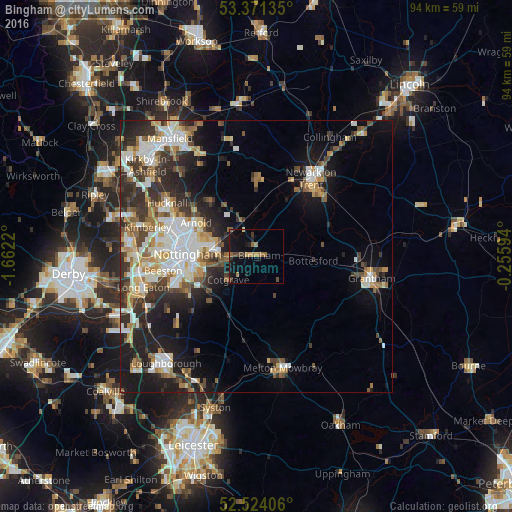
Analysis of Bingham night lights 2016
Square area 10x10 km:
 0%
0%90-99
0%80-89
0.53%70-79
1.46%60-69
2.65%50-59
2.65%40-49
1.72%30-39
2.25%20-29
1.46%10-19
10.05%0-9
77.25%Square area 50x50 km:
3.75%90-99
4.34%80-89
2.17%70-79
2.26%60-69
2.42%50-59
2.54%40-49
2.68%30-39
3.43%20-29
5.82%10-19
10.08%0-9
60.51%Clear (daylight) street map image can be seen on geolist.org.
Map coordinates:
53° 22' 16.9" North, 1° 39' 43.9" West
52° 56' 59.2" North, 0° 57' 32.7" West
52° 31' 26.6" North, 0° 15' 21.4" West
Some cities around Bingham sort by population:
• Nottingham
12.8 km =8 mi,  271°
271°
• West Bridgford
11.4 km =7.1 mi,  258°
258°
• Arnold
12.9 km =8 mi,  295°
295°
• New Basford
14.1 km =8.8 mi,  280°
280°
• Radcliffe on Trent
5.3 km =3.3 mi, 267°
• Cotgrave
7 km =4.3 mi,  228°
228°
• Calverton
12.8 km =8 mi,  319°
319°
• Keyworth
12.4 km =7.7 mi, 225°
2655643 (p: 9,131)
Sources (retrieved 2019-11-25):
» Earth at Night: Flat Maps 2012, 2016