Queensbury night lights from space
Night Light of Queensbury (England) from space (United Kingdom) Src. Average luminocity for 10x10km area is 57.0146% and for 50x50km: 34.2908%.
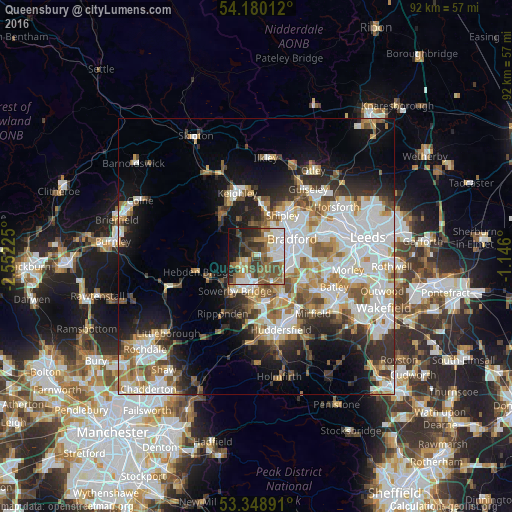
Analysis of Queensbury night lights 2016
Square area 10x10 km:
 10.58%
90-99
11.64%80-89
4.37%70-79
5.42%60-69
11.9%50-59
13.89%40-49
10.19%30-39
10.58%20-29
9.26%10-19
11.11%0-9
1.06%Square area 50x50 km:
9.18%90-99
8.1%80-89
2.77%70-79
3.75%60-69
4.49%50-59
4.31%40-49
3.46%30-39
3.93%20-29
6.16%10-19
10.6%0-9
43.26%Clear (daylight) street map image can be seen on geolist.org.
Map coordinates:
54° 10' 48.4" North, 2° 33' 8.1" West
53° 45' 59.7" North, 1° 50' 56.8" West
53° 20' 56.1" North, 1° 8' 45.6" West
Some cities around Queensbury sort by population:
• Bradford
7.1 km =4.4 mi,  64°
64°
• Halifax
5.5 km =3.4 mi,  180°
180°
• Brighouse
8.2 km =5.1 mi,  148°
148°
• Shipley
9.2 km =5.7 mi,  36°
36°
• Bingley
9.1 km =5.7 mi,  4°
4°
• Elland
9.1 km =5.7 mi, 175°
• Sowerby Bridge
7.5 km =4.7 mi,  211°
211°
• Wilsden
6.1 km =3.8 mi,  353°
353°
2639792 (p: 8,912)
Sources (retrieved 2019-11-25):
» Earth at Night: Flat Maps 2012, 2016