Nantwich night lights from space
Night Light of Nantwich (England) from space (United Kingdom) Src. Average luminocity for 10x10km area is 17.0741% and for 50x50km: 13.1146%.
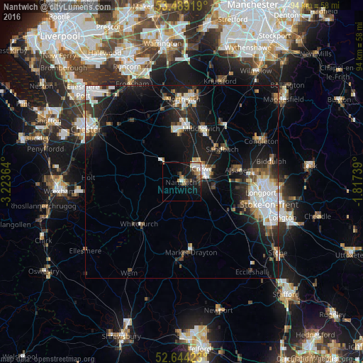
Analysis of Nantwich night lights 2016
Square area 10x10 km:
 2.25%
2.25%90-99
2.25%80-89
2.38%70-79
1.85%60-69
1.98%50-59
3.57%40-49
2.12%30-39
2.51%20-29
1.59%10-19
16.4%0-9
63.1%Square area 50x50 km:
2.73%90-99
2.46%80-89
1.18%70-79
0.92%60-69
1.21%50-59
1.53%40-49
1.63%30-39
1.91%20-29
3.8%10-19
10.48%0-9
72.14%Clear (daylight) street map image can be seen on geolist.org.
Map coordinates:
53° 29' 21.1" North, 3° 13' 25.1" West
53° 4' 7.6" North, 2° 31' 13.8" West
52° 38' 39.2" North, 1° 49' 2.6" West
Some cities around Nantwich sort by population:
• Crewe
6.2 km =3.9 mi,  58°
58°
• Winsford
13.6 km =8.5 mi,  359°
359°
• Sandbach
13.5 km =8.4 mi,  51°
51°
• Middlewich
14.7 km =9.1 mi,  20°
20°
• Alsager
14.6 km =9.1 mi,  77°
77°
• Whitchurch
15.7 km =9.8 mi,  223°
223°
• Audley
14.9 km =9.3 mi,  98°
98°
• Holmes Chapel
18.3 km =11.4 mi,  36°
36°
2641892 (p: 17,226)
Sources (retrieved 2019-11-25):
» Earth at Night: Flat Maps 2012, 2016