Whitchurch night lights from space
Night Light of Whitchurch (England) from space (United Kingdom) Src. Average luminocity for 10x10km area is 1.9246% and for 50x50km: 6.6884%.
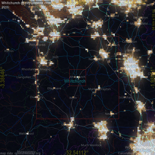
Analysis of Whitchurch night lights 2016
Square area 10x10 km:
 0%
0%90-99
0.53%80-89
0%70-79
0%60-69
0%50-59
0.53%40-49
1.59%30-39
0%20-29
0%10-19
1.06%0-9
96.3%Square area 50x50 km:
0.69%90-99
0.84%80-89
0.49%70-79
0.69%60-69
0.78%50-59
1.04%40-49
1.04%30-39
0.95%20-29
1.63%10-19
8.89%0-9
82.95%Clear (daylight) street map image can be seen on geolist.org.
Map coordinates:
53° 23' 17.1" North, 3° 23' 11.3" West
52° 58' 0" North, 2° 40' 60" West
52° 32' 28" North, 1° 58' 48.8" West
Some cities around Whitchurch sort by population:
• Crewe
21.8 km =13.5 mi,  47°
47°
• Wrexham
22.4 km =13.9 mi,  293°
293°
• Rhosllanerchrugog
25.5 km =15.8 mi,  280°
280°
• Nantwich
15.7 km =9.8 mi,  43°
43°
• Market Drayton
14.6 km =9.1 mi,  117°
117°
• Wem
12.3 km =7.6 mi,  191°
191°
• Coedpoeth
27.1 km =16.8 mi, 290°
• Gresford
23.3 km =14.5 mi,  304°
304°
2634124 (p: 9,710)
Sources (retrieved 2019-11-25):
» Earth at Night: Flat Maps 2012, 2016