Nailsea night lights from space
Night Light of Nailsea (England) from space (United Kingdom) Src. Average luminocity for 10x10km area is 8.6444% and for 50x50km: 16.9227%.
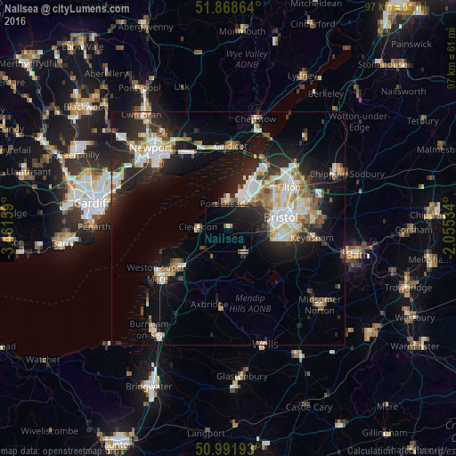

Analysis of Nailsea night lights 2016
Square area 10x10 km:
 0.53%
0.53%90-99
0.13%80-89
0.67%70-79
0.27%60-69
1.2%50-59
1.2%40-49
1.87%30-39
0%20-29
3.88%10-19
15.11%0-9
75.13%Square area 50x50 km:
3.04%90-99
3.59%80-89
1.48%70-79
1.78%60-69
1.62%50-59
2.13%40-49
1.85%30-39
2.08%20-29
5.72%10-19
10.12%0-9
66.6%Clear (daylight) street map image can be seen on geolist.org.
Map coordinates:
51° 52' 7.1" North, 3° 27' 41.7" West
51° 25' 56.6" North, 2° 45' 30.5" West
50° 59' 30.9" North, 2° 3' 19.2" West
Some cities around Nailsea sort by population:
• Bristol
11.5 km =7.1 mi,  77°
77°
• Portishead
5.6 km =3.5 mi,  351°
351°
• Clevedon
7 km =4.3 mi,  279°
279°
• Bishopsworth
9.7 km =6 mi,  101°
101°
• Caldicot
17.1 km =10.6 mi,  0°
0°
• Yatton
6.7 km =4.2 mi,  222°
222°
• Undy
16.4 km =10.2 mi, 346°
• Long Ashton
6.8 km =4.2 mi,  92°
92°
2641913 (p: 20,543)
Sources (retrieved 2019-11-25):
» Earth at Night: Flat Maps 2012, 2016