Caldicot night lights from space
Night Light of Caldicot (Wales) from space (United Kingdom) Src. Average luminocity for 10x10km area is 13.4906% and for 50x50km: 16.5643%.
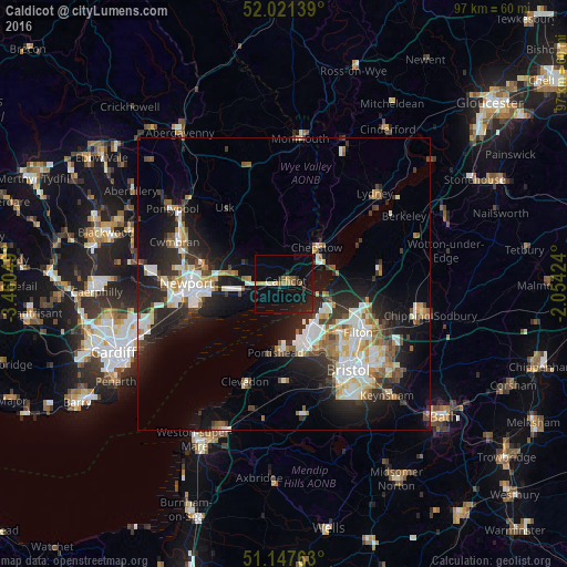
Analysis of Caldicot night lights 2016
Square area 10x10 km:
 0.4%
0.4%90-99
0.94%80-89
0.94%70-79
2.27%60-69
1.87%50-59
2.41%40-49
0.27%30-39
1.07%20-29
4.28%10-19
12.83%0-9
72.73%Square area 50x50 km:
2.95%90-99
3.47%80-89
1.48%70-79
1.69%60-69
1.55%50-59
2.14%40-49
1.76%30-39
2.17%20-29
5.68%10-19
10.3%0-9
66.79%Clear (daylight) street map image can be seen on geolist.org.
Map coordinates:
52° 1' 17" North, 3° 27' 37.8" West
51° 35' 11.8" North, 2° 45' 26.5" West
51° 8' 51.5" North, 2° 3' 15.3" West
Some cities around Caldicot sort by population:
• Newport
16.6 km =10.3 mi,  270°
270°
• Portishead
11.7 km =7.3 mi,  184°
184°
• Chepstow
8.2 km =5.1 mi,  42°
42°
• Stoke Gifford
16.9 km =10.5 mi,  117°
117°
• Thornbury
16.6 km =10.3 mi,  81°
81°
• Caerleon
13.8 km =8.6 mi,  280°
280°
• Magor
5.2 km =3.2 mi,  261°
261°
• Undy
4.1 km =2.5 mi,  252°
252°
2654014 (p: 11,373)
Sources (retrieved 2019-11-25):
» Earth at Night: Flat Maps 2012, 2016