Bishopsworth night lights from space
Night Light of Bishopsworth (England) from space (United Kingdom) Src. Average luminocity for 10x10km area is 41.2874% and for 50x50km: 14.5235%.
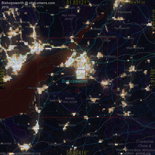
Analysis of Bishopsworth night lights 2016
Square area 10x10 km:
 11.36%
90-99
11.9%80-89
6.95%70-79
1.87%60-69
1.2%50-59
0.8%40-49
0.94%30-39
4.55%20-29
15.11%10-19
23.13%0-9
22.19%Square area 50x50 km:
2.41%90-99
2.95%80-89
1.31%70-79
1.63%60-69
1.63%50-59
2.03%40-49
1.74%30-39
1.71%20-29
3.81%10-19
8.21%0-9
72.56%Clear (daylight) street map image can be seen on geolist.org.
Map coordinates:
51° 51' 4.4" North, 3° 19' 26.1" West
51° 24' 53.2" North, 2° 37' 14.9" West
50° 58' 27" North, 1° 55' 3.6" West
Some cities around Bishopsworth sort by population:
• Bristol
4.8 km =3 mi,  20°
20°
• Kingswood
8.9 km =5.5 mi,  61°
61°
• Mangotsfield
11.5 km =7.1 mi,  44°
44°
• Portishead
12.7 km =7.9 mi,  305°
305°
• Nailsea
9.7 km =6 mi,  281°
281°
• Keynsham
8.5 km =5.3 mi,  90°
90°
• Stoke Gifford
12.6 km =7.8 mi,  26°
26°
• Long Ashton
3.3 km =2.1 mi,  301°
301°
9884034 (p: 11,576)
Sources (retrieved 2019-11-25):
» Earth at Night: Flat Maps 2012, 2016