Knutsford night lights from space
Night Light of Knutsford (England) from space (United Kingdom) Src. Average luminocity for 10x10km area is 9.8662% and for 50x50km: 36.7983%.
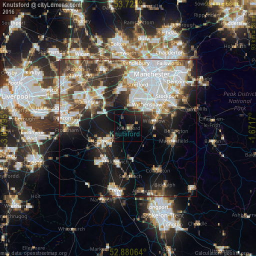
Analysis of Knutsford night lights 2016
Square area 10x10 km:
 0%
0%90-99
0%80-89
0.38%70-79
0.76%60-69
0.38%50-59
1.64%40-49
2.4%30-39
2.53%20-29
6.31%10-19
15.15%0-9
70.45%Square area 50x50 km:
10.31%90-99
8.15%80-89
3.69%70-79
3.61%60-69
3.65%50-59
3.92%40-49
4.67%30-39
5.09%20-29
7%10-19
13.53%0-9
36.38%Clear (daylight) street map image can be seen on geolist.org.
Map coordinates:
53° 43' 15.6" North, 3° 4' 40.6" West
53° 18' 10.4" North, 2° 22' 29.4" West
52° 52' 50.3" North, 1° 40' 18.1" West
Some cities around Knutsford sort by population:
• Northwich
10.8 km =6.7 mi,  243°
243°
• Altrincham
9.6 km =6 mi,  10°
10°
• Wilmslow
9.9 km =6.2 mi,  73°
73°
• Hale
8.8 km =5.5 mi,  18°
18°
• Lymm
11.1 km =6.9 mi,  321°
321°
• Timperley
11.1 km =6.9 mi, 14°
• Bowdon
8.2 km =5.1 mi,  4°
4°
• Holmes Chapel
11.3 km =7 mi,  174°
174°
2645093 (p: 13,191)
Sources (retrieved 2019-11-25):
» Earth at Night: Flat Maps 2012, 2016