Methil night lights from space
Night Light of Methil (Scotland) from space (United Kingdom) Src. Average luminocity for 10x10km area is 14.1435% and for 50x50km: 6.9738%.
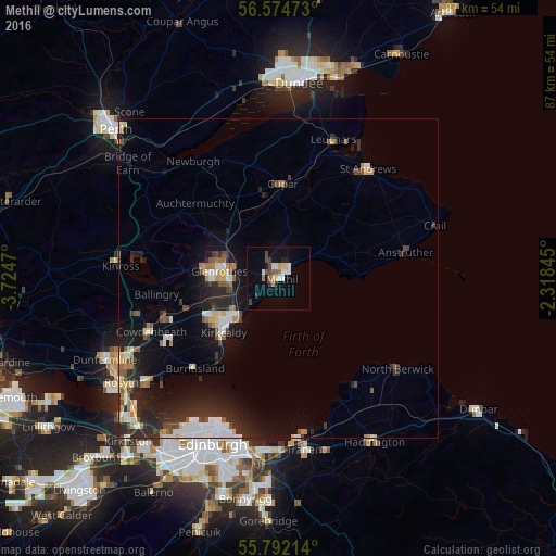
Analysis of Methil night lights 2016
Square area 10x10 km:
 2.51%
2.51%90-99
1.79%80-89
1.44%70-79
1.44%60-69
1.44%50-59
0.96%40-49
2.63%30-39
1.32%20-29
1.79%10-19
5.5%0-9
79.19%Square area 50x50 km:
1.06%90-99
1.24%80-89
0.58%70-79
0.53%60-69
0.85%50-59
0.63%40-49
0.9%30-39
0.77%20-29
3.11%10-19
5.23%0-9
85.1%Clear (daylight) street map image can be seen on geolist.org.
Map coordinates:
56° 34' 29" North, 3° 43' 28.9" West
56° 11' 7.5" North, 3° 1' 17.7" West
55° 47' 31.7" North, 2° 19' 6.4" West
Some cities around Methil sort by population:
• Kirkcaldy
11.5 km =7.1 mi,  228°
228°
• Glenrothes
9.4 km =5.8 mi,  276°
276°
• Cowdenbeath
21.6 km =13.4 mi,  247°
247°
• Cupar
14.8 km =9.2 mi,  2°
2°
• Leven
2.1 km =1.3 mi,  39°
39°
• Lochgelly
18.9 km =11.7 mi, 250°
• Burntisland
19.4 km =12.1 mi,  223°
223°
• Ballingry
19.1 km =11.9 mi,  262°
262°
2642694 (p: 11,160)
Sources (retrieved 2019-11-25):
» Earth at Night: Flat Maps 2012, 2016