Ballingry night lights from space
Night Light of Ballingry (Scotland) from space (United Kingdom) Src. Average luminocity for 10x10km area is 5.0156% and for 50x50km: 12.0877%.
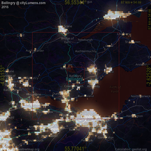
Analysis of Ballingry night lights 2016
Square area 10x10 km:
 0.36%
0.36%90-99
0.12%80-89
0%70-79
0%60-69
0.24%50-59
1.79%40-49
1.67%30-39
1.79%20-29
0.84%10-19
0.84%0-9
92.34%Square area 50x50 km:
2.26%90-99
2.48%80-89
0.98%70-79
0.97%60-69
1.37%50-59
0.93%40-49
1.07%30-39
1.25%20-29
5.01%10-19
9.89%0-9
73.78%Clear (daylight) street map image can be seen on geolist.org.
Map coordinates:
56° 33' 12.4" North, 4° 1' 53.5" West
56° 9' 50.1" North, 3° 19' 42.3" West
55° 46' 13.5" North, 2° 37' 31" West
Some cities around Ballingry sort by population:
• Dunfermline
13.1 km =8.1 mi,  218°
218°
• Kirkcaldy
11.7 km =7.3 mi,  116°
116°
• Glenrothes
10.2 km =6.3 mi,  70°
70°
• Cowdenbeath
5.9 km =3.7 mi,  189°
189°
• Dalgety Bay
14.4 km =8.9 mi, 185°
• Kelty
4.9 km =3 mi,  227°
227°
• Lochgelly
4.1 km =2.5 mi,  163°
163°
• Burntisland
13 km =8.1 mi,  154°
154°
2656551 (p: 5,758)
Sources (retrieved 2019-11-25):
» Earth at Night: Flat Maps 2012, 2016