Lochgelly night lights from space
Night Light of Lochgelly (Scotland) from space (United Kingdom) Src. Average luminocity for 10x10km area is 12.0598% and for 50x50km: 15.7474%.
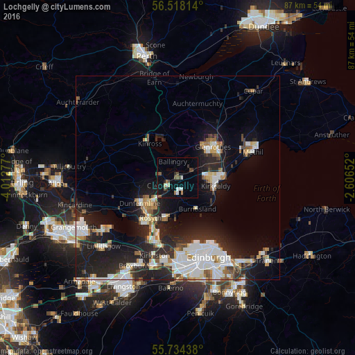
Analysis of Lochgelly night lights 2016
Square area 10x10 km:
 1.32%
1.32%90-99
1.79%80-89
0.72%70-79
0.12%60-69
1.32%50-59
3.23%40-49
2.03%30-39
1.67%20-29
0.72%10-19
8.01%0-9
79.07%Square area 50x50 km:
3.4%90-99
3.62%80-89
1.32%70-79
1.22%60-69
1.62%50-59
1.16%40-49
1.4%30-39
1.51%20-29
6.35%10-19
10.69%0-9
67.72%Clear (daylight) street map image can be seen on geolist.org.
Map coordinates:
56° 31' 5.3" North, 4° 0' 46" West
56° 7' 41.7" North, 3° 18' 34.7" West
55° 44' 3.8" North, 2° 36' 23.5" West
Some cities around Lochgelly sort by population:
• Dunfermline
11.2 km =7 mi,  235°
235°
• Kirkcaldy
9.4 km =5.8 mi,  97°
97°
• Glenrothes
11.3 km =7 mi,  48°
48°
• Cowdenbeath
2.8 km =1.7 mi,  229°
229°
• Dalgety Bay
10.7 km =6.6 mi,  193°
193°
• Kelty
4.8 km =3 mi,  277°
277°
• Burntisland
9 km =5.6 mi,  149°
149°
• Ballingry
4.1 km =2.5 mi,  343°
343°
2643827 (p: 6,586)
Sources (retrieved 2019-11-25):
» Earth at Night: Flat Maps 2012, 2016