Measham night lights from space
Night Light of Measham (England) from space (United Kingdom) Src. Average luminocity for 10x10km area is 10.1806% and for 50x50km: 29.216%.
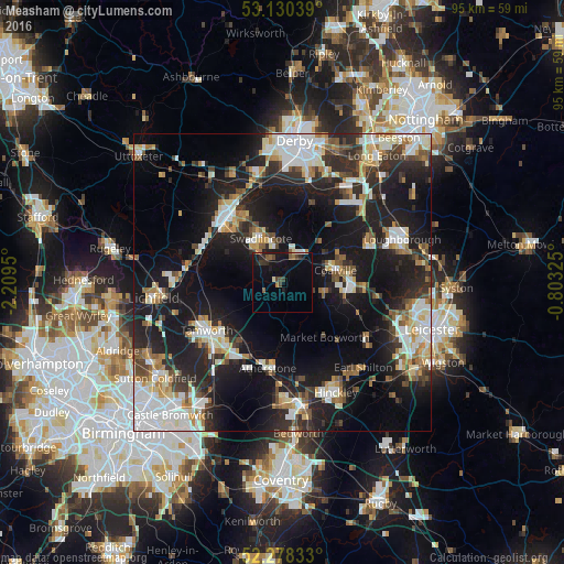
Analysis of Measham night lights 2016
Square area 10x10 km:
 0.13%
0.13%90-99
0.88%80-89
0.51%70-79
0.25%60-69
1.39%50-59
2.27%40-49
2.4%30-39
2.27%20-29
2.27%10-19
13.76%0-9
73.86%Square area 50x50 km:
5.93%90-99
5.72%80-89
2.73%70-79
2.8%60-69
3.13%50-59
2.91%40-49
3.23%30-39
3.73%20-29
9.75%10-19
23.65%0-9
36.4%Clear (daylight) street map image can be seen on geolist.org.
Map coordinates:
53° 7' 49.4" North, 2° 12' 34.2" West
52° 42' 23.2" North, 1° 30' 22.9" West
52° 16' 42" North, 0° 48' 11.7" West
Some cities around Measham sort by population:
• Burton upon Trent
14.5 km =9 mi,  320°
320°
• Tamworth
15.1 km =9.4 mi,  237°
237°
• Swadlincote
8.3 km =5.2 mi,  335°
335°
• Coalville
9.3 km =5.8 mi,  79°
79°
• Ashby de la Zouch
5 km =3.1 mi,  26°
26°
• Atherstone
14.8 km =9.2 mi,  190°
190°
• Polesworth
11.9 km =7.4 mi,  215°
215°
• Ibstock
7.6 km =4.7 mi,  107°
107°
2642843 (p: 5,209)
Sources (retrieved 2019-11-25):
» Earth at Night: Flat Maps 2012, 2016