Ibstock night lights from space
Night Light of Ibstock (England) from space (United Kingdom) Src. Average luminocity for 10x10km area is 17.4921% and for 50x50km: 26.861%.
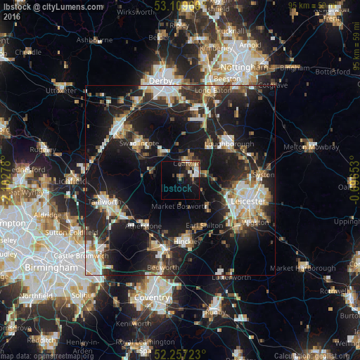
Analysis of Ibstock night lights 2016
Square area 10x10 km:
 2.51%
2.51%90-99
3.57%80-89
1.32%70-79
0.53%60-69
2.51%50-59
4.23%40-49
1.59%30-39
1.32%20-29
2.78%10-19
17.86%0-9
61.77%Square area 50x50 km:
4.39%90-99
5.02%80-89
2.58%70-79
2.63%60-69
2.96%50-59
2.86%40-49
3.31%30-39
4.12%20-29
9.92%10-19
23.63%0-9
38.58%Clear (daylight) street map image can be seen on geolist.org.
Map coordinates:
53° 6' 34.9" North, 2° 6' 10" West
52° 41' 7.9" North, 1° 23' 58.7" West
52° 15' 26" North, 0° 41' 47.5" West
Some cities around Ibstock sort by population:
• Coalville
4.6 km =2.9 mi,  25°
25°
• Earl Shilton
13.4 km =8.3 mi,  154°
154°
• Shepshed
11.6 km =7.2 mi,  39°
39°
• Ashby de la Zouch
8.4 km =5.2 mi,  323°
323°
• Glenfield
14.5 km =9 mi,  107°
107°
• Kirby Muxloe
13.1 km =8.1 mi,  117°
117°
• Anstey
14.3 km =8.9 mi,  95°
95°
• Measham
7.6 km =4.7 mi,  287°
287°
2646311 (p: 5,650)
Sources (retrieved 2019-11-25):
» Earth at Night: Flat Maps 2012, 2016