Atherstone night lights from space
Night Light of Atherstone (England) from space (United Kingdom) Src. Average luminocity for 10x10km area is 20.8029% and for 50x50km: 33.3132%.
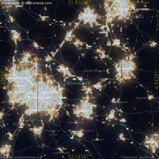
Analysis of Atherstone night lights 2016
Square area 10x10 km:
 3.17%
3.17%90-99
3.31%80-89
1.98%70-79
1.59%60-69
2.12%50-59
0.13%40-49
3.04%30-39
1.98%20-29
5.29%10-19
36.11%0-9
41.27%Square area 50x50 km:
8.15%90-99
7.29%80-89
2.79%70-79
2.83%60-69
3.48%50-59
3.38%40-49
3.48%30-39
3.61%20-29
9.19%10-19
23.07%0-9
32.73%Clear (daylight) street map image can be seen on geolist.org.
Map coordinates:
53° 0' 2.1" North, 2° 15' 0.2" West
52° 34' 31.3" North, 1° 32' 48.9" West
52° 8' 45.5" North, 0° 50' 37.7" West
Some cities around Atherstone sort by population:
• Nuneaton
8 km =5 mi,  136°
136°
• Tamworth
12 km =7.5 mi,  302°
302°
• Hinckley
12.2 km =7.6 mi,  109°
109°
• Bedworth
11.9 km =7.4 mi,  153°
153°
• Hartshill
3.4 km =2.1 mi, 150°
• Attleborough
9.3 km =5.8 mi, 138°
• Polesworth
6.5 km =4 mi,  318°
318°
• Fazeley
11.1 km =6.9 mi,  292°
292°
2656848 (p: 11,237)
Sources (retrieved 2019-11-25):
» Earth at Night: Flat Maps 2012, 2016