Polesworth night lights from space
Night Light of Polesworth (England) from space (United Kingdom) Src. Average luminocity for 10x10km area is 31.9511% and for 50x50km: 34.1117%.
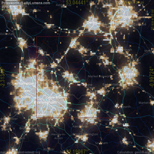
Analysis of Polesworth night lights 2016
Square area 10x10 km:
 6.08%
6.08%90-99
8.6%80-89
2.51%70-79
4.89%60-69
3.44%50-59
0%40-49
3.17%30-39
3.57%20-29
10.58%10-19
22.75%0-9
34.39%Square area 50x50 km:
9.14%90-99
8.18%80-89
3.11%70-79
3.13%60-69
3.24%50-59
2.8%40-49
2.87%30-39
2.76%20-29
7.66%10-19
22.11%0-9
35%Clear (daylight) street map image can be seen on geolist.org.
Map coordinates:
53° 2' 39.9" North, 2° 18' 48.6" West
52° 37' 10.6" North, 1° 36' 37.3" West
52° 11' 26.4" North, 0° 54' 26.1" West
Some cities around Polesworth sort by population:
• Sutton Coldfield
15.1 km =9.4 mi,  247°
247°
• Nuneaton
14.5 km =9 mi,  137°
137°
• Tamworth
6 km =3.7 mi,  285°
285°
• Hartshill
9.9 km =6.2 mi, 143°
• Atherstone
6.5 km =4 mi, 138°
• Attleborough
15.8 km =9.8 mi, 138°
• Fazeley
6 km =3.7 mi,  264°
264°
• Measham
11.9 km =7.4 mi,  35°
35°
2640173 (p: 9,645)
Sources (retrieved 2019-11-25):
» Earth at Night: Flat Maps 2012, 2016