Marlborough night lights from space
Night Light of Marlborough (England) from space (United Kingdom) Src. Average luminocity for 10x10km area is 1.3195% and for 50x50km: 5.6017%.
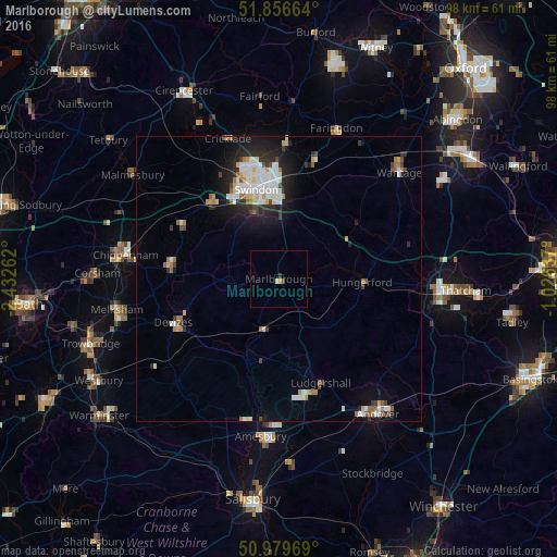
Analysis of Marlborough night lights 2016
Square area 10x10 km:
 0%
0%90-99
0%80-89
0.53%70-79
0.53%60-69
0%50-59
0%40-49
0.53%30-39
0.4%20-29
0.13%10-19
0%0-9
97.86%Square area 50x50 km:
1.08%90-99
1.3%80-89
0.38%70-79
0.5%60-69
0.69%50-59
0.46%40-49
0.47%30-39
0.57%20-29
1.56%10-19
3.06%0-9
89.92%Clear (daylight) street map image can be seen on geolist.org.
Map coordinates:
51° 51' 23.9" North, 2° 25' 57.4" West
51° 25' 13" North, 1° 43' 46.2" West
50° 58' 46.9" North, 1° 1' 34.9" West
Some cities around Marlborough sort by population:
• Swindon
15.7 km =9.8 mi,  346°
346°
• Devizes
19.9 km =12.4 mi,  247°
247°
• Calne
19.3 km =12 mi,  276°
276°
• Royal Wootton Bassett
18.2 km =11.3 mi,  318°
318°
• Tidworth
21.5 km =13.4 mi,  167°
167°
• Wroughton
12.4 km =7.7 mi,  338°
338°
• Lyneham
19.6 km =12.2 mi,  303°
303°
• Hungerford
14.8 km =9.2 mi,  92°
92°
2643010 (p: 8,395)
Sources (retrieved 2019-11-25):
» Earth at Night: Flat Maps 2012, 2016