Irlam night lights from space
Night Light of Irlam (England) from space (United Kingdom) Src. Average luminocity for 10x10km area is 51.8968% and for 50x50km: 49.1189%.
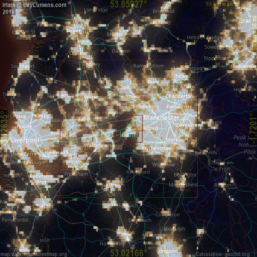
Analysis of Irlam night lights 2016
Square area 10x10 km:
100  12.04%
90-99 10.85%
80-89 2.91%
70-79 5.69%
60-69 7.01%
50-59 5.82%
40-49 3.31%
30-39 14.29%
20-29 32.67%
10-19 5.42%
0-9 0%
12.04%90-99
10.85%80-89
2.91%70-79
5.69%60-69
7.01%50-59
5.82%40-49
3.31%30-39
14.29%20-29
32.67%10-19
5.42%0-9
0%Square area 50x50 km:
100 13.05%
90-99 11.16%
80-89 5.03%
70-79 5.23%
60-69 5.93%
50-59 5.71%
40-49 6.41%
30-39 6.65%
20-29 10.57%
10-19 13.34%
0-9 16.93%
13.05%90-99
11.16%80-89
5.03%70-79
5.23%60-69
5.93%50-59
5.71%40-49
6.41%30-39
6.65%20-29
10.57%10-19
13.34%0-9
16.93%Clear (daylight) street map image can be seen on geolist.org.
Map coordinates:
53° 51' 33.4" North, 3° 7' 34.9" West
53° 26' 33.1" North, 2° 25' 23.6" West
53° 1' 18" North, 1° 43' 12.4" West
Some cities around Irlam sort by population:
• Sale
6.8 km =4.2 mi,  106°
106°
• Stretford
7.1 km =4.4 mi,  83°
83°
• Urmston
4.6 km =2.9 mi, 81°
• Eccles
7.5 km =4.7 mi,  52°
52°
• Lymm
7.7 km =4.8 mi,  207°
207°
• Timperley
7.6 km =4.7 mi,  128°
128°
• Partington
2.7 km =1.7 mi,  187°
187°
• Culcheth
6.5 km =4 mi,  278°
278°
2646042 (p: 19,442)
Sources (retrieved 2019-11-25):
» Earth at Night: Flat Maps 2012, 2016