Lightwater night lights from space
Night Light of Lightwater (England) from space (United Kingdom) Src. Average luminocity for 10x10km area is 27.7885% and for 50x50km: 31.6387%.
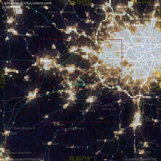
Analysis of Lightwater night lights 2016
Square area 10x10 km:
 0.14%
0.14%90-99
0.14%80-89
1.68%70-79
1.96%60-69
3.08%50-59
7.28%40-49
10.36%30-39
9.94%20-29
19.61%10-19
41.88%0-9
3.92%Square area 50x50 km:
5.66%90-99
6.44%80-89
2.8%70-79
3.33%60-69
3.88%50-59
4.97%40-49
6.11%30-39
5.52%20-29
9.27%10-19
14.2%0-9
37.82%Clear (daylight) street map image can be seen on geolist.org.
Map coordinates:
51° 47' 7.9" North, 1° 22' 28.6" West
51° 20' 54.5" North, 0° 40' 17.3" West
50° 54' 25.9" North, 0° 1' 54" East
Some cities around Lightwater sort by population:
• Woking
8.5 km =5.3 mi,  112°
112°
• Farnborough
8.4 km =5.2 mi,  224°
224°
• Camberley
5.1 km =3.2 mi,  255°
255°
• Crowthorne
8.7 km =5.4 mi,  286°
286°
• Ascot
6.9 km =4.3 mi,  358°
358°
• Frimley
6.2 km =3.9 mi,  235°
235°
• Knaphill
5 km =3.1 mi,  129°
129°
• Bagshot
1.8 km =1.1 mi,  319°
319°
7116406 (p: 6,791)
Sources (retrieved 2019-11-25):
» Earth at Night: Flat Maps 2012, 2016