Bagshot night lights from space
Night Light of Bagshot (England) from space (United Kingdom) Src. Average luminocity for 10x10km area is 32.3067% and for 50x50km: 31.2694%.
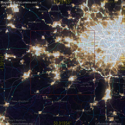
Analysis of Bagshot night lights 2016
Square area 10x10 km:
 0.7%
0.7%90-99
1.68%80-89
2.94%70-79
3.78%60-69
2.52%50-59
6.86%40-49
11.48%30-39
9.8%20-29
24.93%10-19
33.47%0-9
1.82%Square area 50x50 km:
5.33%90-99
6.2%80-89
2.74%70-79
3.28%60-69
3.93%50-59
5.04%40-49
6.27%30-39
5.57%20-29
9.4%10-19
14.72%0-9
37.51%Clear (daylight) street map image can be seen on geolist.org.
Map coordinates:
51° 47' 51.5" North, 1° 23' 28.1" West
51° 21' 38.5" North, 0° 41' 16.9" West
50° 55' 10.3" North, 0° 0' 54.4" East
Some cities around Bagshot sort by population:
• Bracknell
7.3 km =4.5 mi,  323°
323°
• Farnborough
8.8 km =5.5 mi,  212°
212°
• Camberley
4.6 km =2.9 mi,  235°
235°
• Crowthorne
7.3 km =4.5 mi,  278°
278°
• Ascot
5.6 km =3.5 mi,  9°
9°
• Frimley
6.3 km =3.9 mi,  219°
219°
• Knaphill
6.7 km =4.2 mi,  131°
131°
• Lightwater
1.8 km =1.1 mi,  139°
139°
2656632 (p: 5,430)
Sources (retrieved 2019-11-25):
» Earth at Night: Flat Maps 2012, 2016