Knaresborough night lights from space
Night Light of Knaresborough (England) from space (United Kingdom) Src. Average luminocity for 10x10km area is 16.8131% and for 50x50km: 14.6231%.
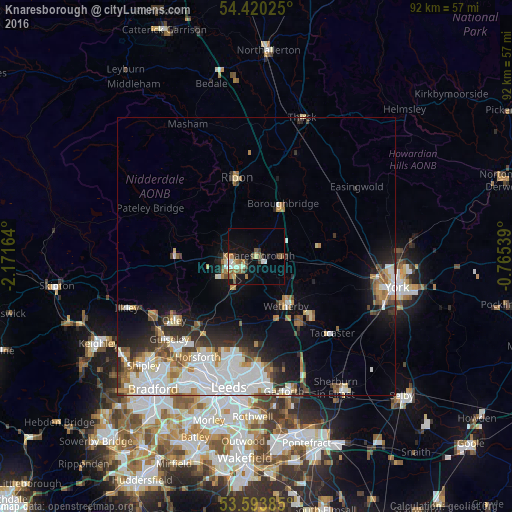
Analysis of Knaresborough night lights 2016
Square area 10x10 km:
 1.14%
1.14%90-99
3.41%80-89
1.52%70-79
1.52%60-69
2.53%50-59
3.79%40-49
2.65%30-39
2.15%20-29
0%10-19
14.77%0-9
66.54%Square area 50x50 km:
3.97%90-99
3.42%80-89
1.05%70-79
1.32%60-69
1.8%50-59
1.42%40-49
1.33%30-39
1.68%20-29
2.67%10-19
5.5%0-9
75.86%Clear (daylight) street map image can be seen on geolist.org.
Map coordinates:
54° 25' 12.9" North, 2° 10' 17.9" West
54° 0' 32.8" North, 1° 28' 6.6" West
53° 35' 37.9" North, 0° 45' 55.4" West
Some cities around Knaresborough sort by population:
• Harrogate
4.9 km =3 mi,  245°
245°
• Yeadon
21.5 km =13.4 mi,  221°
221°
• Chapel Allerton
20.5 km =12.7 mi,  192°
192°
• Ripon
14.6 km =9.1 mi,  344°
344°
• Otley
18.7 km =11.6 mi,  232°
232°
• Wetherby
10.5 km =6.5 mi,  149°
149°
• Tadcaster
19.4 km =12.1 mi,  136°
136°
• Boston Spa
14.2 km =8.8 mi, 145°
2645163 (p: 14,740)
Sources (retrieved 2019-11-25):
» Earth at Night: Flat Maps 2012, 2016