Wetherby night lights from space
Night Light of Wetherby (England) from space (United Kingdom) Src. Average luminocity for 10x10km area is 15.4325% and for 50x50km: 24.0789%.
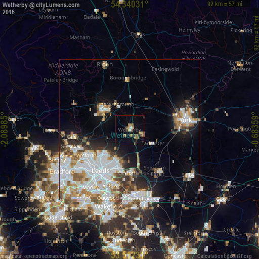
Analysis of Wetherby night lights 2016
Square area 10x10 km:
 0.93%
0.93%90-99
1.06%80-89
1.59%70-79
2.51%60-69
4.5%50-59
2.25%40-49
1.72%30-39
1.32%20-29
1.32%10-19
7.14%0-9
75.66%Square area 50x50 km:
7.05%90-99
5.96%80-89
1.84%70-79
2.4%60-69
2.87%50-59
2.18%40-49
2.28%30-39
2.5%20-29
3.34%10-19
7.3%0-9
62.28%Clear (daylight) street map image can be seen on geolist.org.
Map coordinates:
54° 20' 25.1" North, 2° 5' 23.5" West
53° 55' 42.1" North, 1° 23' 12.2" West
53° 30' 44.3" North, 0° 41' 0.9" West
Some cities around Wetherby sort by population:
• Harrogate
12.1 km =7.5 mi,  305°
305°
• Chapel Allerton
14.9 km =9.3 mi,  221°
221°
• Kippax
18 km =11.2 mi,  176°
176°
• Garforth
15.2 km =9.4 mi, 178°
• Knaresborough
10.5 km =6.5 mi,  329°
329°
• Sherburn in Elmet
17.4 km =10.8 mi,  148°
148°
• Tadcaster
9.5 km =5.9 mi,  121°
121°
• Boston Spa
3.8 km =2.4 mi,  134°
134°
2634217 (p: 13,572)
Sources (retrieved 2019-11-25):
» Earth at Night: Flat Maps 2012, 2016