Chapel Allerton night lights from space
Night Light of Chapel Allerton (England) from space (United Kingdom) Src. Average luminocity for 10x10km area is 86.0106% and for 50x50km: 36.0055%.
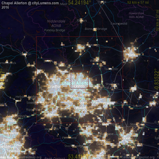
Analysis of Chapel Allerton night lights 2016
Square area 10x10 km:
 44.71%
90-99
28.84%80-89
1.06%70-79
5.42%60-69
2.91%50-59
2.38%40-49
3.31%30-39
7.14%20-29
4.23%10-19
0%0-9
0%Square area 50x50 km:
9.6%90-99
8.38%80-89
3.03%70-79
3.64%60-69
4.34%50-59
4.35%40-49
4.02%30-39
5.03%20-29
7.78%10-19
9.88%0-9
39.94%Clear (daylight) street map image can be seen on geolist.org.
Map coordinates:
54° 14' 31" North, 2° 14' 29.3" West
53° 49' 44.4" North, 1° 32' 18" West
53° 24' 43.1" North, 0° 50' 6.8" West
Some cities around Chapel Allerton sort by population:
• Leeds
3.7 km =2.3 mi,  189°
189°
• Morley
10.7 km =6.6 mi,  201°
201°
• Yeadon
10.5 km =6.5 mi,  291°
291°
• Pudsey
8.9 km =5.5 mi,  245°
245°
• Lofthouse
11.4 km =7.1 mi,  166°
166°
• Horsforth
6.7 km =4.2 mi,  283°
283°
• Garforth
11.2 km =7 mi,  111°
111°
• Holbeck
5.4 km =3.4 mi, 201°
6695247 (p: 18,206)
Sources (retrieved 2019-11-25):
» Earth at Night: Flat Maps 2012, 2016